
SECTION A
Answer ALL questions in this section.
1.(a) Define weather (2marks)
(b) State five factors considered when siting a weather station. (5marks)
2.(a) State two ways that make it possible for geographers to study the earth’s interior. (2marks)
(b) State 3 changes that may occur in a rock after it has undergone metamorphism. (3marks)
3.(a) Differentiate between folding and faulting. (2marks)
(b) Citing an example on each period, state 4 orogenesisperiods in fold mountain formation. (4marks)
4.(a) Differentiate between a spring and a well. (2marks)
(b) State three ways by which springs develop. (3marks)
5.Give two ways in which mulching improves soil. (2marks)
SECTION B
Answer question 6 and any other two questions from this section
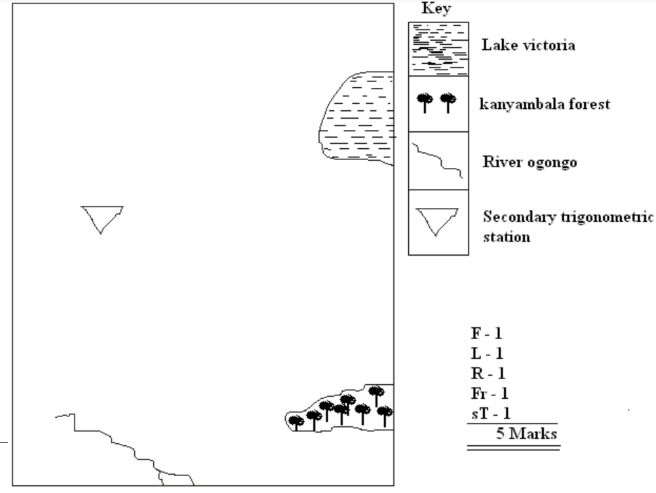
6.Study the map of Homabay (1:50,000) sheet 129/2 provided.
Answer the following questions.
(i) Calculate the area of the part of Olambwe Valley National Reserve shown on the map.
(Give your answer in square kilometers). (2marks)
(ii) What is the length of the Homa Bay municipality boundary? (2marks)
(iii) Give six figure grid reference for the secondary trigonometric section on the Ruri Hills. (2marks)
(iv) Draw a rectangle that measures 10cm by 15cm to represent the area enclosed by Eastings 51 and 59 and Northings 33 and 45. On it mark and name the following features.
Lake Victoria
Ranyambala forests
Secondary trigonometric station
River Ogongo (5marks)
Using evidence from the map, state three functions of Homabay town (3marks)
(i) Name three types of vegetation shown on the map. (3marks)
(ii) Identify three settlement patterns found in the area covered by the map. (3marks)
Describe the relief of the area covered by the map. (5marks)
7. (a) Define the term vulcanicity (2marks)
(b) Give four characteristics of a composite volcano. (4marks)
(c) Describe how a lava plateau is formed. (4marks)
(d) Explain four negative effects of vulcanicity. (8marks)
(e) You intend to carry out a field study of an area affected by vulcanicity.
Give four sources of information that you would use in the preparation for the study (4marks)
Give three factors that would make it difficult for you to collect accurate data during the field study. (3marks)
(a) Give three agents of weathering (3marks)
(b) Describe frost action as a process of weathering. (4marks)
(c) Explain how an exfoliation dome is formed. (5marks)
(d) Explain 3 factors that influence the rate of mass wasting. (6marks)
State four slow types of mass wasting. (4marks)
Give three positive effects of mass wasting. (3marks)
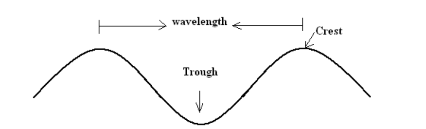
9. (a) (i) State three factors that influence transportation of materials in the sea. (3marks)
(ii) Draw a simple well labeled diagram of a sea wave. (3marks)
(iii)Give three ways in which islands are formed. (3 marks)
(b) Explain the following processes of wave erosion.
Hydraulic action (3marks)
Solution (2marks)
(c) Describe the formation of a spit. (5marks)
(d) Explain 3 economic importances of coastal landforms. (6marks)
10. (a) State four physical factors that contribute to development of deserts. (4marks)
(b) Give four characteristics of desert landscape. (4marks)
(c) Explain three factors that influence wind transport in the desert. (6marks)
(d) Describe how a deflation hollow is formed. (4marks)
(e) You carried out a field study in a desert landscape.
State four preparations for your study. (4marks)
List three water depositional features you identified. (3marks)
Marking Scheme
Question 1.(a) Weather is the condition of the atmosphere of a given place over a given period of time/ shot period of time. (3 marks)
(b) Five factors considered when siting a weather station.Secure place; should be sited in a secure place to avoid vandalism and theft.The site should be away from obstruction (e.g. buildings, vegetation).The site should be relatively flat and free from flooding.The site should be in an open space where there’s free flow of air.The site should have a wide view of surrounding landscape and sky.
Question2.(a) Ways that make it possible for geographers to study the earth’s interior.By studying seismic shock wavesThrough study of volcanic lava flowsThrough study of rocks on the moon and meteoritesThrough very deep mining drilling. (1 x 2 = 2mks) any 2 points
(b) Changes that may occur in a rock after it has undergone metamorphismNew minerals are formedRocks change in hardnessThe rock change in physical appearanceRock particles become compactedMinerals recrystalise further. (1 x 3 = 3mks)
Question3.
(a) Differentiate between folding and faulting.Folding is the bending of crustal rocks due to earth movements whileFaulting is the breaking / fracturing of crustal rocks due to tectonic forces.
(b) 4 orogenesis periods in fold mountains formation.Charnianorogeny: e.g. African block, Laurentian shield, Russian platform & Deccan Plateau.Caledonian Orogeny: e.g. Akwapim hills, Scottish HighlandsHercynian Orogeny: e.g. Cape ranges, Appalachian Mtns, UralAlpine Orogeny: e.g. Atlas, Alps, Himalayas, Rockies & Andes Mountains. (1 x 4= 4mks)
Question4.(a) Differentiate between a spring and a well.A spring is a place on the surface of the earth where underground water flows out onto the surface whileA well is a relatively deep hole in the ground which is dug by people for the purpose of getting water.
(1 x 2 = 2mks)
(b) Ways by which springs develop.When a permeable rock lies on top of an impermeable rock.When the hilly country rocks are well jointed.When a dyke acts as a damWhen limestone rocks (escarpments) overlie impermeable rocks.When gently sloping layers of permeable rock alternate with layers of impermeable rock.
Any 3 (1 x 3 = 3mks)
Question5.(a) Two ways in which mulching improves soil.Enhancing infiltration / reduce run off.Protect soil against splash erosionEnable soil to regain fertility / add humus to soilEnable moisture retention / reduces excess evaporation. Any 2 pints ( 1 x 2 = 2mks)
SECTION B
Question 6(a) (i) 21km2 2marks(ii) 6.2 km 2marks 4fig (1mk)(iii) 517 388 2marks 6fig (1mk)
(b) Using evidence from the map, state three functions of Homabay townFunction EvidenceIndustrial centre GinneryHealth centre HospitalEducational centre Schools/ nursing training, farmers training centreTransport centre Roads / PierCommunication centre Post officeTrading centre Market Any 3 ( 3×1=3mks)NB: The point should be qualified (evidence) to earn a mark
(c) (i) 3 types of vegetationForestsPapyrus swampScrub (3 marks)(ii) Settlement patternsLinearNucleatedDispersal (3 marks)
(d) Describe the relief of the area covered by the map.The area between Easting 51 and 54 is hilly as indicated by the presence of Ruri HillsThe West of the area covered by the map is flat as indicated by widely spaced contour.There are rivers valleys around Ruri HillsAround Olambwe East the region is very steep as indicated by dense contours.The land is plainsland around Olambwe Valley national reserve.( 1 x 5 = 5mks)
Question 7
(a)Definition of vulcanicityIt’s the processes through which solids, liquids, gaseous and molten materials are forced out of the earth’s interior or are intruded into the earth’s crust. (1×2 = 2 marks)
(b)Four characteristics of a composite volcano.Has vertical vent / pipe/ fissureComposed of alternating layers of ash / lavaIts conical in shape / steep sidedHas side ventsIts made up of acidic lava / viscous lavaHas conelets / parasitic conesAt the summit, it may have caldera / crater / plug. (4 x 1 = 4mks)
(c) How a lava plateau is formed.Formed when magma reaches the earth’s surface through fissures / ventsLava is ultra basic / low intensityLava flows over a long distance spreading over a large area before cooling.Lava cools slowly forming an extensive lava platform bounded by steep slopes.(4 x 1 = 4mks)
(d)Four negative effects of vulcanicity.Volcanic eruptions can result in loss of livesVolcanic eruptions can destroy propertyWeathered volcanic rocks / materials e.g. ashes and granite can result in infertile soils.Volcanic features like mountains create barriers to transport and communicationThe rugged nature of volcanic landscape discourages economic activities e.g. agriculture and settlement.Volcanic eruptions produce poisonous gases e.g. sulphur Co2 which pollute the environment / threaten human life.Volcanic mountains create a rain shadow effect which discourage farming activitiesRecent lava flows have immature soils which are not suitable for farming.Volcanic eruptions and related hazards cause panic and affect people psychologically / inhibit development.Dust particles from volcanic eruptions absorb and scatter solar energy, lowering global temperatures; resulting to health problems to man.Volcanic eruptions may cover / burry minerals making mining difficulty and expensive.
(4×2 = 8 marks)
(i) Four sources of information that you would use in the preparation for the studyWritten materials / magazines/ newspapers / text booksMapsPhotographs / filmsResource personsElectronic media e.g. T.V / radio (4 x 1 = 4mks)
(ii) Three factors that would make it difficult for you to collect accurate data during the field studyFear of eruptionsInaccessibility of some areas due to piled up lavaInadequate information because people have been evacuatedThere may be restrictions to access the area. (3 x 1 = 3mks)
Question 8
(a) Three agents of weatheringHeat / temperatureWater / rainfall / moisturePlantsAnimalsManWind (3 x 1 = 3mks)
(b) Frost action as a process of weathering.Occurs where temperatures are within the freezing pointWhen temperatures rise, snow melt and water enters the crack in the rockWhen temperatures drop, the water freezes, expands and widens the cracksContinued process of freezing and thawing lead to break up of rocks.(4 x 1 = 4mks)
(c) Explain how an exfoliation done is formed.High temperatures during the day causes rocks to expandAt night temperatures are low hence rocks contractRepeated expansion and contraction cause stress on the rocks hence cracks develop.Eventually, the outer layer peels off leading to rounded mass of rock known as exfoliation dome.Further wind action may smoothen the surfaces.
(5 x 1 = 5mks)
(d) 3 factors that influence the rate of mass wasting.Steep slopes increase the rate of mass wastingThe heavier the material, the faster the movement of the materialThe higher the rainfall the faster the movement of the materialBare surface increase the rate of the movement of the materialEarth movements trigger movement of materialsHuman activities e.g. mining / farming / construction accelerate the rate of materials movement.
(3 x 2 = 6mks)
(e) Four slow types of mass wasting.Soil creepTalus creepSolifluctionScree creepRock creep (4 x 1 = 4mks)
(f)Three positive effects of mass wasting.Create scenery that attract tourists for foreign exchangeIt facilitates deposition of rich soils for agriculture in the low landsLandslides create barriers across river courses / valley leading to formation of lakes.It causes slope retreat encouraging human activities (3 x 1 = 3mks)Question 9
(i) Three factors that influence transportation of materials in the sea.Ocean currentsTidal currentsStrength of wavesNature of materialsDepth of waterSlope of the coast / shorealignment of the coast Any 3 x 1 = 3 mks(ii) A simple well labeled diagram of a sea wave. 3marks
(iii)Three ways in which islands are formed.Volcanic eruptionAccumulation of coral into coral reefsSubmergence of an upland coastDeposition across the bays / river mouths / lagoonsErosion of head lands(any 3 x 1 = 3mks)
(i) Hydraulic actionAction caused by the force of moving water in form of wavesInvolves direct wave force where the pounding force of the wave causes shattering of rocks on the cliff /causes compression of air in the cracks.As the wave retreats, the air expands explosively.Gradually the rock disintegrates. Any 3 x 1 = 3mks
(ii) SolutionIs the process where sea water dissolves soluble minerals in the rock which are in contact with it on the sea side and bed.2 x 1 = 2mksFormation of a spit.It forms on a shallow shore at a point where there is a change in the angle of the coastlineSand and shingles are deposited from the headland seaward by long shore drift / oblique waves.Continued deposition leads into accumulation of materials seawards.With time, an elongated ridge of sand and shingles with one end attached to the mainland and the other projecting into the sea called a spit is formed. Any 5 x 1 = 5mks3 economic importances of coastal landforms.Coastal rocks e.g. coral limestone are used in building and constructionLimestone rock is used as a raw material in cement industriesCoastal features like coral reef attract tourist who bring in foreign exchangeFiord and rias provide suitable sites for construction of the harbours / breeding of fishMarine life is used in education and researchMud flats and mangroves swamps are drained and used for rice cultivation / mangrove forests are exploited to provide poles for constructionExtensive coastal plains provide suitable sites for human settlements and agriculture. Any 3 x 2 = 6mks
Question 10
(a) Four physical factors that contribute to development of deserts.Continentality / distance from large water bodiesA place being located in an area with descending winds / anticyclonesRain shadow effectProlonged droughtsCold ocean currentsProlonged / persisted high temperaturesClimate change / global warmingPersistent offshore / dry winds / cold winds Any 4 x 1 = 4 mks
(b) Four characteristics of desert landscape.Most of the ground is bare / scanty vegetationTotal absence / partial surface waterWind is dorminant leading to desert sand stormsLand surface is covered by fine sand / stones / rock outcropsGalleys / badlands are commonThin soilsLittle organic matter.Any 4 x 1 = 4mks
(c) Three factors that influence wind transport in the desert.Speed and the force / strength of the windNature of the load / either light / heavyIntervening obstacles e.g. dead animals , twig or rockWater mass / rain / moisture. Any well explained 3 x 2 = 6mks
(d) How a deflation hollow is formed.A pre-existing depression /localized fault is exposed to wind erosion.Wind eddies remove the unconsolidated materials by with deflationWeathering aids in breaking down the exposed rockWind abrasion excavates the depression by eroding the rock along weak linesThe depression is deepened and widened as a deflation continues to remove the loose materials leading to formation of a large depression known as deflation hollow. Any 4 x 1 = 4mks
(e)(i)Four preparations for your study.Seeking permissionConduct a reconnaissanceFormulate / adjust hypothesis and objectivesChoose methods of data collectionAssemble necessary tools / materialsPrepare a working scheduleDivide the students into groupsDiscuss the topic in classLiterature review Any 4 x 1 = 4mks
(ii) List three water depositional features you identified.Salina / playa
Alluvial fans / cones
Bajadas3 x 1 = 3mks
