
2015 KCSE Geography Past Paper
SECTION A
Answer all the questions in this section.
1. The diagram below represents the structure of the earth. Use it to answer question (a).
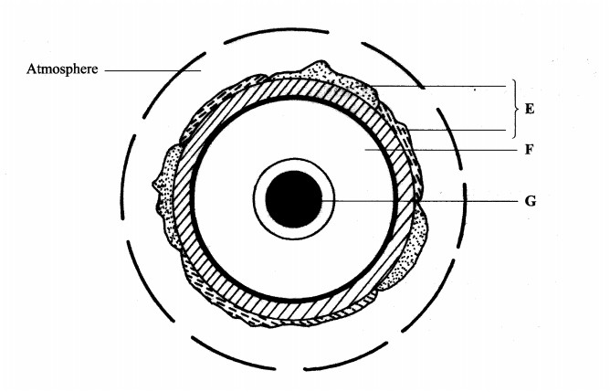
(a) Name:
(i) the layers marked E and F. (2 marks)
(ii) the minerals that make up the layer marked G. (2 marks)
(b) Give two effects of the rotation of the earth on its axis. (2 marks)
2. (a) What is a metamorphic rock? (2 marks)
(b) Give three examples of metamorphic rocks. (3 marks)
3. (a) Name two types of boundaries according to the plate tectonic theory.(2 marks)
(b) Give three effects of the movement of tectonic plates. (3 marks)
4. (a) What is an earthquake? (2 marks)
(b) Identify the scale used to measure:
(i) the intensity of earthquakes; (1 mark)
(ii) the magnitude of earthquakes. (l mark)
5. (a) Give three characteristics of a river in its middle stage. (3 marks)
The diagram below shows a Bird’s foot delta. Use it to answer question (b).
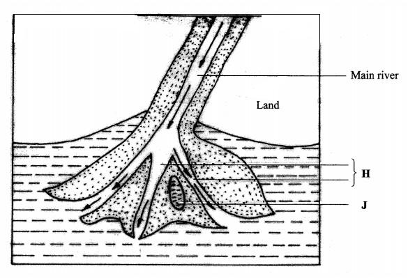
(b) Identify the features marked H and J. (2 marks)
SECTION B
Answer question 6 and any other two questions from this section.
6. Study the map of Busia 1:50,000 (sheet 101/1) provided and answer the following questions.
(a) (i) Convert the ratio scale of the map extract into a statement scale. (2 marks)
(ii) What is the general direction of flow of river Sio? (1 mark)
(iii) Identify the two dominant types of natural vegetation shown in the area covered by the map.(2 marks)
(b) Draw a square 10 cm by 10 cm to represent the area to the west of Easting 30 and north of Northing 40. On the square, mark and label:
(i) an international boundary;
(ii) an air photo principal point;
(iii) river Sio;
(iv) the area above 1200 metres above sea level. (5 marks)
(c) Describe the relief of the area covered by the map (5 marks)
(d) (i) Explain how the following factors have influenced the distribution of settlements in the area covered by the map: drainage; (2 marks)transport. (2 marks)
(ii) Citing evidence from the map, state three functions of Funyula town. (6 marks)
7. (a)(i) Define the term weather. (2 marks)
(ii) Explain how the following factors influence weather: cloud cover; (4 marks)local winds. (4 marks)
The diagram below represents a weather measuring instrument. Use it to answer question (b).
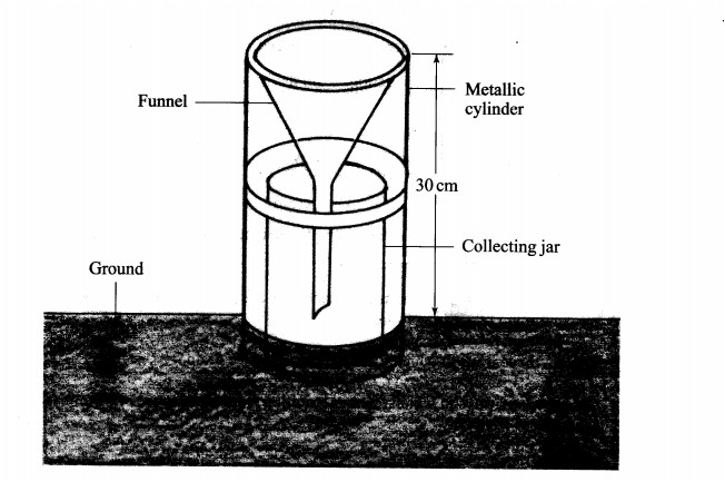
(b) (i) Which element of weather is measured using the instrument shown above? (1 mark)
(ii) Describe how the above instrument is used. (3 marks)
8 (b) Explain how the following factors influence the amount of underground water in limestone areas:
(i) rainfall; (4 marks)
(ii) vegetation cover, (4 marks)
(c) (i) Apart from stalagrnites, name three other underground features formed in limestone areas. (3 marks)
(ii) With the aid of a diagram, describe how a stalagmite is fomred. (8 marks)
(d) Give three reasons why there are few settlements in Karst landscapes. (3 marks)
Paper 2
SECTION A: (25 marks)
Answer all the questions in this section.
1 (a) Define the term environment. (2 marks)
(b) Give three effects of air pollution in major urban centres. (3 marks)
2 (a) Identify three factors that influence the occurrence of minerals. (3 marks)
(b) Name the area Where the following minerals are mined in Kenya:
(i) diatomite; (1 mark)
(ii) salt. (1 mark)
3 (a) Distinguish between forest and forestry. (2 marks)
(b) Identify three activities that may be undertaken in your school to conserve trees. (3 marks)
4 Give four challenges facing Nomadic pastoralism in Kenya. (4 marks)
5 Use the map of Kenya below to answer question (a).
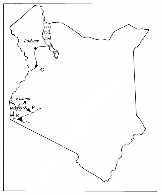
(a) Name the hydro-electric power projects marked E, F and G. (3 marks)
(b) State three advantages of geothermal power as a source of energy. (3 marks)
SECTION B (75 marks)
Answer question 6 and any other two questions in this section.
6 The table below shows the value of some of Kenya’s mineral exports from 2008 to 2014. Use it to answer questions (a) and (b).
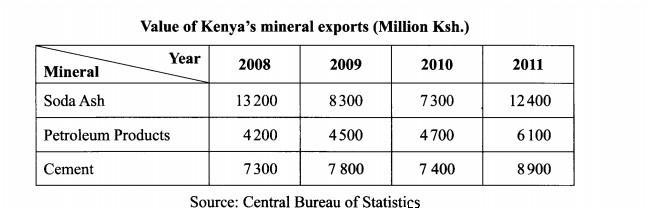
(a) (i) Using a scale of l cm to represent l000 million Kenya Shillings, draw a comparative bar graph to represent the data shown. (8 marks)
(ii)State three advantages of using comparative bar graphs to represent statistical data. (3 marks)
(b) Calculate the percentage increase in value of exports between the years 2010 and 2011. (6 marks)
(c) Explain the significance of trade to the economy of Kenya. (8 marks)
7 (a)State three physical conditions which favour large scale sugarcane growing in Kenya. (3 marks)
(b) (i) Describe the stages involved in the processing of sugarcane at the factory. (6 marks)
(ii) Give three by-products obtained from sugarcane. (3 marks)
(c) Explain three ways in which the Kenya Government is promoting the sugar manufacturing industry. (6 marks)
(d) Your class visited a sugarcane plantation for a field study on land preparation and planting.
(i) Outline four activities that you are likely to identify. (4 marks)
(ii) Give three methods you would use to record data during the field study. (3 marks)
8 (a) Differentiate between domestic and international tourism.(2 marks) Use the map of East Africa below to answer question (b).
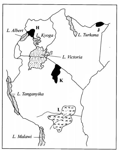
(b) Name:
(i) The national parks marked H, J and K. (3 marks)
(ii) The game reserve marked L. (1 mark)
(c) (i) Explain how the following factors influence tourism in Kenya.climate; (2 marks)scenery; (2 marks)tour companies. (2 marks)
(iii) State five effects of floods on tourism. (5 marks)
(d) Explain four ways in which the county governments in Kenya would promote sustainable tourism. (8 marks)
9 Use the map of Africa below to answer question (a)
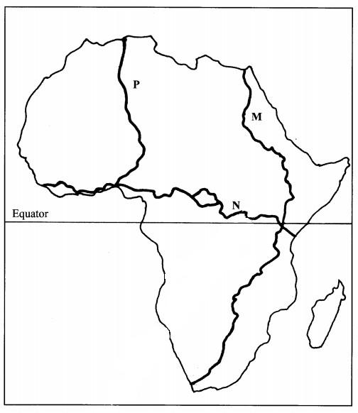
(a) Name the trans-continental highways in Africa marked M, N and P. (3 marks)
(b) (i) State four advantages of air transport. (4 marks)
(ii) Explain four efforts that the Kenya Government has taken to improve air transport. (8 marks)
(c) (i) Identify two types of communication. (2 marks)
(ii) Explain four problems facing communication in Africa. (8 marks)
10 (i) Give two main sources of population data. (2 marks)
(ii) Outline the information that can be derived from a population pyramid. (3 marks)
(b) Explain how the following factors have led to population increase in Kenya
(i) cultural beliefs; (2 marks)
(ii) migration (2 marks)
(c) Explain four problems which result from a high population growth rate in Kenya.(8 marks)
(d) Describe four ways in which the population of Kenya differs from that of Sweden. (8 marks)
