
2019 KCSE Geography paper 1 Past Paper
SECTION A
Answer all the questions in this section.
1. (a) Distinguish between Geography and Environment.(2 marks)
(b) Identify the two branches of Geography.(2 marks)
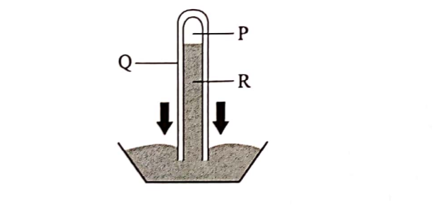
2. (a) The diagram below represents an instrument for measuring atmospheric pressure.
Name the parts marked P, Q and R.(3 marks)
(b) State three benefits of weather forecasting to human activities.(3 marks)
3. Give four proofs that support the theory of continental drift.(4 marks)
4. (a) Give three factors that influence the way a river transports its load.(3 marks)
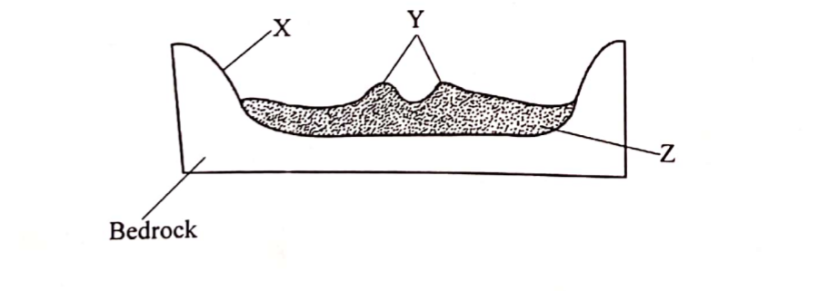
(b) The diagram below represents a cross-section of a flood plain. Name the features marked X, Y and Z. (3 marks)
5. (a) State the two causes of vertical movement of the ocean water.(2 marks)
(b) List three types of ocean tides.(3 marks)
SECTION B
Answer question 6 and any other two questions from fhis section.
6. Study the map of Yimbo 1: 50,000 (sheet l 15/1) provided and answer the following questions.
(â) (Î) What is the magnetic variation of the map?(2 marks)
(ii) Identify two natural features found at the grid square 3597.(2 marks)
(iii) Identify the two countries represented in the area covered by the map. (2 marks)
(b) (i) Give the direction of the trigonometrical station at the grid square 2789 from the air photo principal point at Nyagoma Mission School. (2 marks)
(ii) Measure the length of the provincial boundary to the North West of the area covered by the map. Give your answer in kilometres. (2 marks)
(c) (i) Give evidence that show the area covered by the map receives low rainfall. (3 marks)
(ii) Explain how each of the following factors have influenced the distribution of settlements in the area covered by the map:
I. Transport(2 marks)
II. Vegetation (2 marks)
III. Relief (2 marks)
(d) Describe the drainage of the area covered by the map.(6 marks)
7. (a) Using examples from East Africa, describe each of the following types of volcanoes:
(i) Active Volcano(3 marks)
(ii) Dormant Volcano(4 marks)
(b) Using a well labelled diagram, explain how each of the following features were formed:
(:) Composite Volcano (6 marks)
(ii) Volcanic plug (4 marks)
(c) Explain four negative effects of vulcanicity (8 marks)
8. (a) (i) Apart from inter tropical convergence zone (ITCZ), list four physical factors that influence climaie. (4 marks)
(ii) Give four charactcristics of inier tropical convergence zone (ITCZ). (4 marks)
(b) (i) Name the thrce equatorial climatic regions of Kenya. (3 marks)
(ii) Describe the tundra climate.(6 marks)
(c) Explain four human causes of desertification.(8 marks)
9. (a) (i) Define an ocean.(2 marks)
(ii) Explain the three causes of variation in the amount of salt in ocean water. * (6 marks)
(b) (i) Identify three processes involved in wave erosion. (3 marks)
(ii) With the aid of well labelled diagrams, describe the processes through which a wave cut platform is formed. (8 marks)
(c) You intend to carry out a field study on types of features resulting from wave deposition along the coast.
(i) Identify three methods you would use to record data. (3 marks)
(ii) Give three wave depositional features you are likely to observe during the field study.(3 marks)
10. (a) List three components of soil.(3 marks)
(b) Explain each of the following in relation to the classificati on of soil:
(i) Zonal(2 marks)
(ii) Intrazonal (2 marks)
(iii) Azonal (2 marks)
(c) Explain three causes of soil degeneration.(6 marks)
(d) Students from mwema school visited a nearby ranch to study types of soil.
(i) Explain why they carried the following tools:
i. Hoes (2 marks)
II. Polythene bags (2 marks)
(ii) Give three reasons why they would need to seek permission from relevant authorities. (3 marks)
(iii) List three types of soil erosion they are likely to observe. (3 marks)
2019 KCSE Geography paper 1 Past Paper-Marking Scheme/Answers
SECTION A
Answer all the questions in this section.
1.Distinguish between Geography and Environment
Geography refers to the study of the distribution of natural and human features/phenomenon and their interrelationship on the earth surface while Environment refers to external conditions that surround an organism and has influence on its behaviour.
(b) Identify the two branches of Geography.(2 marks)
– Physical Geography
– Huma Geography
2. (a) The diagram below represents an instrument for measuring atmospheric pressure.
Name the parts marked P, Q and R.(3 marks)
P – Vacuum
Q – Glass tube
R – Mercury
(b) State three benefits of weather forecasting to human activities.(3 marks)
– It enables farmers to plan their farming activities.
– It helps in guiding tourist activities.
– It enables military personnel to plan their military activities.
– It enables people to choose suitable clothing.
– It guides people on sporting activities.
– It guides people on fishing activities.
– It helps to determine the times for air/sea.
3. Give four proofs that support the theory of continental drift.(4 marks) Some continents seem to fit geometrically/ jigsaw fit along the coastal margins There are similarities between the fossils of flora and fauna found on both sides of Atlantic Ocean. / Paleontological/Paleo zoological evidence. Some geological structure can be traced from one continent to another. There are similarities in the past climate in the different parts of the world. /Paleo climatological evidence. There are continuous mountain ranges made up of young volcanic rocks at the mid Atlantic. The shores of Red Sea exhibits evidence of having undergone lateral displacement. /Sea floor spreading. Paleo magnetic evidence/minerals with same alignment are found in different continents adjacent to one another. Similarity of fauna/flora in different continents (Congo & Amazon).
4. (a) Give three factors that influence the way a river transports its load.(3 marks) The volume of water. The gradient of the slope. The nature of the load. The velocity of the river. The amount of the load
(b) The diagram below represents a cross-section of a flood plain.
Name the features marked X, Y and Z. (3 marks)X — BluffY — LeveesZ —Alluvium
5. (a) State the two causes of vertical movement of the ocean water.(2 marks)The differences in the density. The convergence of ocean currents.
(b) List three types of ocean tides.(3 marks) Spring tides Neap tides Perigian tides Apogean tides.
SECTION B
Answer question 6 and any other two questions from this section.
6. Study the map of Yimbo 1: 50,000 (sheet l 15/1) provided and answer the following questions.
(a) (i) What is the magnetic variation of the map?(2 marks)
– 2°28’
(ii) Identify two natural features found at the grid square 3597.(2 marks)Scrub River Meanders papyrus swamp Scattered trees Thicket Papyrus Vegetation Gentle Slope River Valley
(iii) Identify the two countries represented in the area covered by the map. (2 marks)
– Kenya
– Uganda
(b) (i) Give the direction of the trigonometrical station at the grid square 2789 from the air photo principal point at Nyagoma Mission School. (2 marks)North West.
(ii) Measure the length of the provincial boundary to the North West of the area covered by the map. Give your answer in kilometres. (2 marks)6.1km ± 0.1
(c) (i) Give evidence that show the area covered by the map receives low rainfall. (3 marks) Presence of scattered trees. Presence scrub vegetation. Presence of seasonal rivers/seasonal swamps. Presence of reservoir dams/water holes.
(ii) Explain how each of the following factors have influenced the distribution of settlements in the area covered by the map:
I. Transport(2 marks) Along the roads/unmotorable tracks/footpaths, there is linear settlement. At road junctions there are clustered/nucleated settlements. Vegetation There are no settlements within the woodland/thickets/areas where there are papyrus swamp/vegetation. Most of the areas covered by scrub/scattered trees have clustered/ nucleated settlement.
II. Vegetation (2 marks)There are no settlements within the woodland/thickets/areas where there are papyrus swamp/vegetation. Most of the areas covered by scrub/scattered trees have clustered/ nucleated settlement.
III. Relief (2 marks)There are no/few settlements on the hills/isolated islands in the lake. There are clustered/nucleated settlements on the undulating land.
(d) Describe the drainage of the area covered by the map.(6 marks)The area has many permanent rivers. There are seasonal rivers. /Indefinite. There are lakes — Lake Sare, Lake Victoria. The main drainage pattern is Lake Victoria There are papyrus swamps/seasonal swamps. There are manmade reservoirs/dams. Some rivers form dendritic drainage pattern along River Yala. Most of the rivers are draining into Lake Victoria. There are disappearing/vanishing rivers. There is a pond (3891). There is a water hole (2882). The main River is Yala.
7. (a) Using examples from East Africa, describe each of the following types of volcanoes:
(i) Active Volcano(3 marks)They erupted in the recent past. They show current volcanic activities. They are likely to erupt, any time. For examples, Ol donyo Lengai in Tanzania.
(ii) Dormant Volcano(4 marks)This is a volcano that is not active. It has not shown any signs of activity in the recent past. It erupted in the last 500 years. It is likely to erupt again, example is mount Longonot, Menengai, Suswa, Mount Kilimanjaro Tanzania.
(b) Using a well labelled diagram, explain how each of the following features were formed:
(i) Composite Volcano (6 marks)It is formed as a result of central volcanic eruptions. Violent eruption forms a layer of ash. The violence ceases and lava pours out forming a layer of lava on top of the ash. Lava also escapes from the sides of the cone to form conelet/ parasitic cone. A volcanic cone is made up of ash and lava layers built up over a long period of time as a result of many eruptions.
(ii) Volcanic plug (4 marks) A volcano is exposed to agents of erosion and weathering over a prolonged period of time. This exposes a remnant of lava which had solidified inside the vent of the volcano because it is more resistant. Continued erosion of surrounding rocks leads to formation of a steep sided neck of solid lava on top of a volcano. The steep sided neck is called a volcanic plug.
(c) Explain four negative effects of vulcanization (8 marks) Volcanic eruptions cause loss of life/livestock. Some volcanic eruptions may cause great damage to property/ infrastructure/buildings. It may lead to emission of dangerous/poisonous gases that result to death/affect environment./pollution. It causes powerful sea waves/tsunami that can drown coastal islands. Volcanic mountains create rain shadow on the leeward side causing dryness and this discourages agriculture. Volcanic mountains may be barriers to construction of infrastructure, making it expensive. The rugged nature of volcanic landscape make settlement/agriculture difficult. Volcanic lava flows over agricultural land Eruption of volcanic ash & dust may hinder air transport.
8. (a) (i) Apart from inter tropical convergence zone (ITCZ), list four physical factors that influence climate.(4 marks) Latitude Altitude Distance from the sea/continenta1ity Aspect Ocean currents Winds/air masses Configuration/alignment of the coastline
(ii) Give four characteristics of inner tropical convergence zone (ITCZ). (4 marks)It experiences high temperature. It has low pressure/Doldrums. It is a zone where South East and North East trade wind converge.
The zone migrates North and South of the equator with the apparent movement of the overhead sun. It is associated with convectional rainfall, high rainfall (1000- 2000mm) It’s is associated with high humidity
(b) (i) Name the three equatorial climatic regions of Kenya. (3 marks) Modified equatorial climate of the Coast. Modified equatorial climate of North Western margin/border. Modified equatorial climate of Lake the region.
(ii) Describe the tundra climate.(6 marks) It is found above 66½° north/artic circle and above 66½° south of the equator/Antarctic circle. It has cold winters /with temperatures varying between. —29°C to – 40°C . It has very long winters/ lasting 8 months. It has cool summers/ with temperatures of about 10°C – 15°C. It has short summers lasting 3 months. It has a very large annual range/ of temperature going up to 73°C. There is permanent cover of snow and ice/permafrost. The area is generally dry/ with low annual precipitation/ of 100 — 250mm. During the long cold winters, polar winds are dominant. Snow storms/blizzards are common in this region. High pressure zone Low humidity
(c) Explain four human causes of desertification.(8 marks) Deforestation which interferes with the hydrological cycle leading to low rainfall. Poor cultivation practices which has led to soil degeneration and reduction of vegetation. Poor irrigation practices which lead to excessive accumulation of salts in the top soil hindering growth of vegetation/lowering of the water table leading to acidity. Industrialization which has led to depletion of ozone layer thus leading to increased temperature and high rates of evaporation. Overgrazing/overstocking which leads to destruction of vegetation interfering with the hydrological cycle. Overdrawing of ground water leads to lowering the water table.
9. (a) (i) Define an ocean.(2 marks)An ocean is an extensive body of saline water occupying a large basin between continents.
(ii) Explain the three causes of variation in the amount of salt in ocean water. (6 marks) High temperature in ocean water results to high evaporation which leaves behind higher salt concentration. Fresh water added to the oceans through rainfall and melt ice reduces concentration of salts in the ocean. Upwelling of water and ocean currents leads to mixing of ocean water causing variation in concentration of salts.
(b) (i) Identify three processes involved in wave erosion. (3 marks) Corrasion/abrasion Hydraulic action/quarrying action Attrition Solution/corrosion
(ii) With the aid of well labelled diagrams, describe the processes through which a wave cut platform is formed. (8 marks) During high tides, there is undercutting at the base of the cliff by wave erosion/ forming a notch. Continued wave erosion enlarges the notch to form a cave. The hanging rocks above the cave will wither and collapse.
(c) You intend to carry out a field study on types of features resulting from wave deposition along the coast.
(i) Identify three methods you would use to record data. (3 marks) Photographing /videos. Field sketching/drawing diagrams. Note taking. Filling in questionnaires. Tape recording.
(ii) Give three wave depositional features you are likely to observe during the field study.(3 marks)Mud flats/salt marshes Tombolo/Bay bar/offshore bar Beaches/beach cusps/beach ridges Cuspate forelands Dune belts Spit.
10. (a) List three components of soil.(3 marks)Mineral particles/inorganic matter Humus /organic matter Water Air
(b) Explain each of the following in relation to the classification of soil:
(i) Zonal(2 marks)These are mature soils that have undergone long time soil formation/have a well developed soil profile/mature soils.
(ii) Intrazonal (2 marks)These are soils that are formed under poor drainage conditions/ waterlogged areas.
(iii) Azonal (2 marks)These are young soils that have not been affected by soil forming processes/they do not have a well developed soil profile/they are immature and skeletal.
(c) Explain three causes of soil degeneration.(6 marks) Poor agricultural practices such as burning of land/over cultivation/ monoculture/over cropping cause soil to be deficient in some mineral nutrients leading to loss of soil fertility. Excessive/wrong application of fertilizer may affect the soil pH making it too acidic interfering with soil micro-organisms. Leaching due heavy rainfall can lead to percolation of soil nutrients to the lower horizons leading to deficiency of the top soil. Excessive drought leads to accumulation of salts in the top soil making it saline. Soil erosion interferes with soil structure leading to loss of top fertile soil. Other human activities such as quarrying/construction of roads interfere with soil structure leading soil degeneration.
(d) Students from mwema school visited a nearby ranch to study types of soil.
(i) Explain why they carried the following tools:
i. Hoes (2 marks)
• Hoes – To enable them dig up the soil samples.
ii Polythene bags
– To help them carry soil samples.
(ii) Give three reasons why they would need to seek permission from relevant authorities. (3 marks) To be permitted to enter the ranch. To enable the ranch administration to organize for a guide to take them around. To be allowed by the Principal to be away from the school. To alert other teachers that their learners will be away that day.
(iii) List three types of soil erosion they are likely to observe. (3 marks) Splash erosion Gulley erosion Sheet erosion Rill erosion
