
SECTION A
ANSWER ALL QUESTIONS IN THIS SECTION
1.a. Define the term Geography (2mks)
b. What is the relationship between Geography and Biology (2mks)
2.a. Use the diagram below to answer the following questions
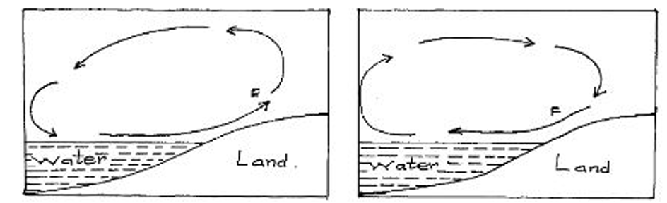
i. Name the air currents marked E (1mk)
ii. Why is the air current marked F flow at night (3mks)
b. Give reason why air cools as it rises (2mks)
3.a. Define folding (2mks)
b. List four types of folds (4mks)
- The diagram below illustrate a mass wasting process. Use it to answer question (a) and (b)
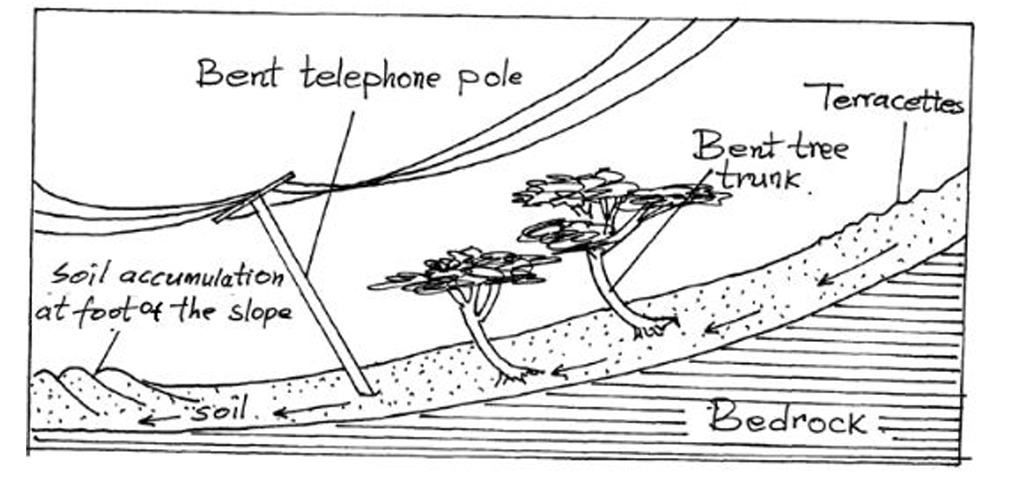
a. Identify the process (1mk)
b. Explain how the process occurs (3mks)
5.a. What is a river profile (2mks)
b. Name the three stages of a river profile (3mks)
SECTION B
ANSWER QUESTION 6 AND OTHER TWO QUESTION FROM THIS SECTION
6.a.i. Give the latitudinal and the longitudinal position of the south west corner of the map extract (2mks)
ii. Calculate the magnetic declination of the map extract (2mks)
b.i. Which adjoining sheet is to the S.E of the area covered by the map? (1mk)
ii. What is the general flow of river Chanya (2mks)
iii. Give three social function of Nyeri town (3mks)
c. Calculate the area of Nyeri Forest to the East of Easting 69 and North of Northing 56. (Give your answer in Kilometre squared(Km2) (2mks)
d. Citing evidence from the map. Give
i. Two reasons why the area is covered by the map is suitable for coffee growing (4mks)
ii. Two factor that favor saw milling in the area covered by the map (4mks)
e. Describe drainage of the area covered by the map (Smarks)
7.a.i. Define the term rock (2mks)
ii. Give two way of classifying rocks (2mks)
b.i. Describe the following characteristic of minerals (6mks)
• Lustre
• Colour
• Hardness
ii. Give the changes that occur on sedimentary rocks when subjected to intense heat and pressure (4mks)
C.i. State the condition necessary for the growth of coral (3mks)
ii. Describe how coral rocks are formed (4mks)
d. You are planning to carry out a field study on rocks
i. List two methods of recording data you are likely to use (2mks)
ii. Give two follow up activities of your study (2mks)
8.a. What is Vulcanicity (2mks)
b.i. Apart from Sill name other intrusive Volcanic features (3mks)
ii. Describe how the following features are formed
I. A sill (Smks)
II. Hotspring (Smks)
iii. Differentiate between a lava and a magma (2mks)
iv. Explain four negative effects of vulcanicity (8mks)
9.a.i. What is the process through which wave transport the eroded materials along the coast (1mk)
ii. Give three factors that influence wave deposition (3mks)
b.i. Name two types of submerged coast (2mks)
ii. State three characteristic of emerged highland coast (3mks)
c. By the use of well labelled diagrams, describe the formation of a spit. (7mks)
d. Student from Moi secondary school were planning to conduct a field study on wave erosional features to areas along the coast.
i. Give three activities they will undertake while in the field (3mks)
ii. Name three erosional features they are likely to identify (3mks)
iii. Outline three problems they are likely to face while in the field (3mks)
10.a.i. Identify two processes in which ice erodes (2mks)
ii. Name four types of glacial moraine (4mks)
b. Give three ways in which ice moves (3mks)
C.i. Apart from Aretes, identify three other ice erosional features in highland areas (3mks)
ii. Describe how an Aretes is formed (Smks)
d. Explain the significance of upland glaciated features to human activities (8mks)
Marking Scheme
- a. Define the term Geography (2mks)
• Is the descriptive study of the distribution and inter-relationship of natural and human phenomena on the earth’s surface.
b. What is the relationship between Geography and Biology (2mks)
• Biology applies to geographical information to explain factors determining the distribution of organisms
2.a. Use the diagram below to answer the following questions
i. Name the air currents marked E (1mk)
• Sea breeze
ii. Why is the air current marked F flow at night (3mks)
• At night, land loses heat faster than sea. Air upon the land becomes cooler and heavier than that upon the sea. The relatively warmer air upon the sea is lighter and therefore it rises while the cooler heavier air on the land flows towards the sea to replace the rising air.
iii. Give reason why air cools as it rises (2mks)
• As air rises it expands thus spreading out its molecules over a wider area and hence becoming cooler
3.a. Define folding (2mks)
• Its bedding of rocks in the crust due to tectonic forces during earth movement
b. List four types of folds (4mks)
• Simple / Symmetrical fold
• Asymmetrical / monoclinal fold
• Overfold
• Icoclinal
• Recumbet
• Nappe
• Anticlinorium and Synclinorium complex
- The diagram below illustrate a mass wasting process. Use it to answer question (a) and (b)
a. Identify the process (1mk),
• Soil Creep
b. Explain how the process occurs (3mks)
• Occurs on gentle slopes
• The air along the gentle slope undergoes through some disturbance/stress
• This cause continuous steady/intermittent movement of the soil down slope
5.a. What is a river profile (2mks)
• It’s is the entire length of the river’s course from its source to its mouth
b. Name the three stages of a river profile (3mks)
• Youthful / upper stage
• Mature/Middle stage
• Old /Lower stage
6.a.i. Give the latitudinal and the longitudinal position of the south west corner of the map extract (2mks)
• Latitude: 0° 30’S
• Longitude 36o45’E
ii. Calculate the magnetic declination of the map extract (2mks)
• l°31’
b.i. Which adjoining sheet is to the S.E of the area covered by the map? (1mk)
• Fort Hall(Muranga)
ii. What is the general flow of river Chanya (2mks)
• Eastwards / West to East
iii. Give three social function of Nyeri town (3mks)
• Educational centre
• Religious centre
• Health centre
• Recreational centre
• Adminisrative centre
c. Calculate the area of Nyeri Forest to the East of Easting 69 and North of Northing 56. (Give your answer in KiIometre squared(Km2) (2mks)
• Complete = 2
• Incomplete = 20
• Area = = 12Km2
d. Citing evidence from the map. Give
i. Two reasons why the area is covered by the map is suitable for coffee growing (4mks)
• The area receive high rainfall suitable for crop farming as evidenced by many permanent rivers/forest vegetation.
• Gentle sloping landscape for proper drainage as evidenced by widely spaced contours
• High altitude above 1500 metres that provides cool condition suitable for coffee farming
• Availability of transport as evidenced by many roads
• Availability of labor evidenced by dense settlements
ii. Two factor that favor saw milling in the area covered by the map (4mks)
• Presences of extensive forest to provide raw materials
• Availability of transport by roads for transporting sawn timber and logs
• Presence of many settlements which provide markets for products
e. Describe drainage of the area covered by the map (5 marks)
• The main drainage features are rivers
• There are many permanent rivers
• Most of the rivers form dendritic drainage pattern
• The main rivers in the area are the river Chanya and Ambani
• Most of the river flow from Abardere forest
• Most of the rivers flows to the East of the area covered by map
7.a.i. Define the term rock (2mks)
• Any naturally formed solid mineral aggregate/ a naturally solid material that is composed of one or a combination of minerals.
ii. Give two way of classifying rocks (2mks)
• Based on their age
• Based on their chemical characteristics and physical properties
• Based on their mode of formation
b.i. Describe the following characteristic of minerals (6mks)
• Lustre
• Mineral differ on their brightness depending on the nature of their reflective surface
• Colour
• Different minerals display different color
• Hardness
• Different minerals have different degree of hardness
ii. Give the changes that occur on sedimentary rocks when subjected to intense heat and pressure (4 mks)
• Rocks are metamorphosed
• New minerals are formed
• Minerals recrystallize further
• Rocks particles become compacted
• The physical appearance of the rock changes
C.i. State the condition necessary for the growth of coral (3mks)
• Warm ocean waters
• Salty ocean waters
• Clear ocean water/silt free
• Shallow water
• Well oxygenated water
ii. Describe how coral rocks are formed (4mks)
• Tiny marine organisms called coral polyps live in colonies in the sea
• Polyps extract calcium from sea water to make their shells
• The polyps die and their hard skeletons of calcium carbonate accumulate into solid mass
• Successive colonies grow on the solid mass, thus rock grows is size
• The spaces between the dead coral polyps are cemented by calcareous algae
d. You are planning to carry out a field study on rocks
i. List two methods of recording data you are likely to use (2mks)
• Filling in questionnaires
• Labeling of samples
• Taking notes
• Photographing
• Drawing sketch maps
ii. Give two follow up activities of your study (2mks)
• Displaying samples of rocks
• Displaying photographs
• Writing/Giving reports
• Reading in books to gather more information
• Holding discussion
8.a. What is Vulcanicity (2mks)
• This the process by which solids, liquids and gases are forced into the earths crust or onto the earth surface.
b.i. Apart from Sill, name other intrusive Volcanic features (3mks)
• Dykes/ dike
• Laccolith/ Laccolite
• Batholith / Bathylith
• Lopolith/Lapolith
• Phacolith / Phacolite
ii. Describe how the following features are formed
I. A sill (5 mks)
• Magma under high pressure enters crystal rocks.
• The semi-fluid rocks/ magma force itself into horizontal cracks/fissures.
• The magma cools and solidifies in horizontal cracks or bedding plane
• The horizontal sheet of igneous rock is the sill
II. Hotspring (5mks)
• Rain water enters the crustal rocks through fissures
• The water reaches a zone of hot igredes rocks
• The water is superheated
• The super-heated water changes to water vapor
• The vapor is under high pressure and so forces its way up heating the ground water. The heated water under pressure flows out continuously to form hot springs
iii. Differentiate between a lava and a magma (2mks)
• -Lava refers to molten rocks materials that has reached the earth’s surface while magma refers to molten rock below the crustal rocks
iv. Explain four negative effects of vulcanicity (8mks)
• On the Leeward side of the volcanic mountain there is a rain shadow effect that discourages settlements and farming.
• Some poisonous gases may be produced during volcanic activity causing respiratory diseases and death
• Volcanic mountains form barriers to the construction of communication and transport lines due to steepness
• Young volcanic soils with young profile form poor soils / soils deficient of nutrients, discouraging agriculture’
• Rugged landscape/steep slopes discourages settlements and farming activities
9.a.i. What is the process through which wave transport the eroded materials along the coast (1mk)
• Long shore drift
ii. Give three factors that influence wave deposition (3mks)
• Presence of abundant supply of materials to be deposited
• presence of shallow shore/continental shelf
• Presence of a wave with strong swash and weak backwash/constructive wave
• Wave deposition should be stronger than erosion
• presences of gentle sloping land at the sea shore
b.i. Name two types of submerged coast (2mks)
• Ria
• Fiord/fjord
• Dalmacian/Longitidinal
ii. state three characteristic of emerged highland coast (3mks)
• It has raised cliffs
• It has raised beach
• It has raised wave-cut platform
• It has raised caves
• It has raised coral
c. By the use of well labelled diagrams, describe the formation of a spit. (7mks)
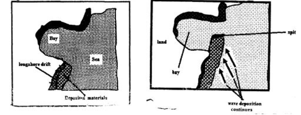
• It forms at the shallow shore at the point where there is a change in the angles of the coastline
• Sand/shingle is deposited by longshore drift/oblique waves
• Deposition continuous and materials accumulate seaward, with time an elongated feature with one end attached to the main land project into the sea called a spit
d. Student from Moi secondary school were planning to conduct a field study on wave erosional features to areas along the coast.
i. Give three activities they will undertake while in the field (3mks)
• Observing
• Taking photographs
• Taking notes
• Administering questions
• Drawing sketch maps
• Asking and answering questions
ii. Name three erosional features they are likely to identify (3mks)
• Stack
• Stump
• Gloup
• Wave-out platform
• Geo
• Caves
• Cliffs
iii. Outline three problems they are likely to face while in the field (3mks)
• Shortage of time
• Attack by dangerous wild animal/insect
• Fatigue
• Inaccessibility to some areas
10.a.i. Identify two processes in which ice erodes (2mks)
• Plucking
• Abrassion
ii. Name four types of glacial moraine (4mks)
• Lateral moraine
• Medial moraine
• Terminal morain
• -Ground moraine/sub-glacial moraine
• Recessional Moraine
• Push moraine
b. Give three ways in which ice moves (3mks)
• Basal slip
• Plastic flowage
• Extension flow
C.i. Apart from Aretes, identify three other ice erosional features in highland areas (3mks)
• Pyramidal peak
• cirque
• Hanging valley
• U-shaped valley
ii. Describe how an Aretes is formed (5 mks)
• Formed when two adjacent cracks/hollows exist on a mountain side
• The two hollows/cracks are filled within ice
• The ice erodes the sides through plucking and deepens the hollow through abrasion
• Through plucking the back wall of the hollows slowly recedes
• Eventually the hollows/cirques are separated by knife edged ridge called arete
d. Explain the significance of upland glaciated features to human activities (8mks)
• The warm glaciated valleys are suitable for livestock farming/cultivation.
• Glacial upland areas from magnificent features that encourages recreation and tourism
• Glaciated mountains discourage human settlement hence the growth of forest from lumbering.
• Waterfalls formed in glaciated uplands provides suitable sites for hydroelectric power production
• Corrie lake/ tarns offer suitable areas for trout fishing
• U-shaped valleys form natural route ways
• Fjord coastlines form deep well sheltered natural harbors/good fish grounds
