
2011 KCSE Geography Past Paper
3.2.1 Geography Paper 1 (312/1)
SECTION A
Answer ALL the questions in this section.
1 The diagram below shows the angles of the sun’s rays at different latitudes when the sun is at the equator.
Use it to answer questions (a) and (b).
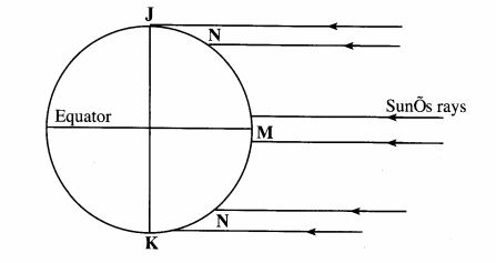
(a) Name the parts of the earth’s surface marked J and K. (2 marks)
(b) Give two reasons why the intensity of the insulation is higher at M than at N, (2 marks)
2 (a) What is Weathering? (2 marks)
(b) Give three factors that influence the rate of weathering. (3 marks)
3 The diagram below shows a composite volcano
(a) Name the features marked P, Q and R.(3 marks)
(b) How is a parasitic cone formed?(3 marks)
4 (a) What is land breeze?(2 marks)
(b) Give two ways in which sea breezes influence the adjacent land.(2 marks)
5 The diagram below shows ways through which wind transports its load.
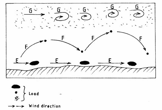
(a) Name the three ways labelled E, F and G. (3 marks)
(b) Name three features produced by wind abrasion in arid areas. (3 marks)
SECTION B
Answer question 6 and any two other questions from this section.
6 Study the map of Nkubu (1 :50,000) sheet 122/1 provided and answer the following questions.
(i) Give the latitudinal and longitudinal position of the North East corner of the map extract. (2 marks)
(ii) Give two methods used to represent relief on the map. (2 marks)
(iii) What is the relief feature found at the top of Kirui Hill within Mt. Kenya forest. (1 mark)
(iv) Apart from administration. give three other services that are provided at Nkubu Divisional Headquarters. (3 marks)
(b) (i) What is the length in kilometers of the all-Weather bound surface road from the bridge at Nkubu water works (509935) to the road junction near Gitimbi (509995)? (2 marks)
(ii) State three problems that may be encountered during construction of roads in the area covered by the map. (3 marks)
(c) Citing evidence from the map, give three reasons why cattle rearing is widespread in Nkubu area. (6 marks)
(d) Describe the drainage of the area covered by the map. (6 marks)
7 (a) (i) State three conditions that are necessary for siting a weather station. (3 marks)
(ii) Give four reasons why weather forecasting is important. (4 marks)
(b) The table below shows the temperature and rainfall figures for a weather station in Kenya. Use it to answer question (b) and (c).
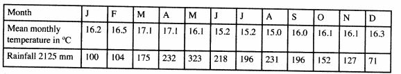
Calculate:
(i) The mean annual temperature for the station. (2 marks)
(ii) The annual range of temperature for the station. (2 marks)
(c) (i) On the graph paper provided, draw a bar graph to represent the rainfall figures for the station. Use a vertical scale of 1cm to represent 20mm. (5 marks)
(ii) Describe the characteristics of the climate experienced at the weather station. (3 marks)
(d) Suppose you visited a weather station for a field study on weather;
(i) Give three methods you would use to collect data. (3 marks)
(ii) State three advantages of studying weather through fieldwork. (3 marks)
8 The map below shows the location of some mountain ranges.
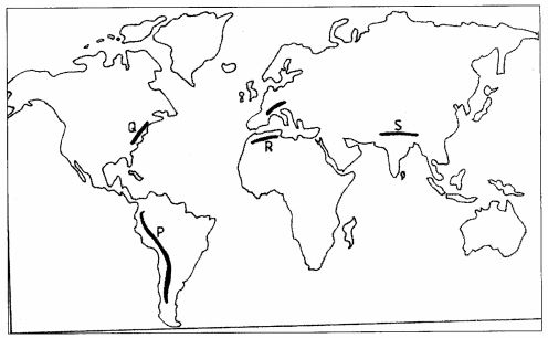
(a) Name the ranges marked P, Q, R and S. (4 marks)
(b) (i) Apart from fold mountains, name three other features resulting from folding. ( 3 marks)
(ii) With the aid of labelled diagrams, describe how fold mountains are formed. (10 marks)
(c) Explain the significance of fold mountains to human activities. (8 marks)
9 (a) (i) What are tides? (2 marks)
(ii) Give three causes of ocean currents. (3 marks) (iii) Name the three ocean currents along the western coast of Africa. (3 marks)
(b) (i) State three characteristics of submerged lowland coasts. (3 marks)
(ii) Explain three factors that determine the rate of coastal erosion. (6 marks)
(c) With the aid of labelled diagrams, describe the process through which a stack is formed. (8 marks)
10 (a) (i) What is a lake? (2 marks)
(ii) Name two crater lakes in Kenya. (2 marks)
(b) Describe how the following lakes are formed.
(i) corrie lake(4 marks)
(ii) oasis(4 marks)
(iii) lagoon.(4 marks)
(c) (i) Give three reasons why some lakes in Kenya have saline water.(3 marks)
( ii) Explain how each of the following has affected lakes in Kenya:
-deforestation(2 marks)
-industrialization(2 marks)
-water needs.(2 marks)
3.2.2 Geography Paper 2 (312/2)
SECTION A
Answer all the questions in this section.
1 (a) Name two exotic breeds of commercial beef cattle reared in Kenya. (2 marks)
(b) Outline two similarities of commercial beef cattle fanning in Kenya and Argentina. (2 marks)
2 (a) Define the term fisheries. (2 marks)
(b) State three ways in which marine fisheries in Kenya can be conserved. (3 marks)
3 (a) Name two prairie provinces of Canada where wheat is grown on a large scale. (2 marks)
(b) Give three physical conditions that favour large scale wheat farming in the prairie provinces of Canada. (3 marks)
4 (a) State three reasons why paper milling industries are located near rivers. (3 marks)
(b) Name three industries in Kenya that use agricultural non-food products as raw materials. (3 marks)
5 (a) State three measures which the government of Kenya has taken to reduce infant mortality. (3 marks)
(b) Give two negative effects of low population growth in a country. (2 marks)
SECTION B
Answer question 6 and any other two questions from this section.
6 Study the photograph below and use it to answer question (a)
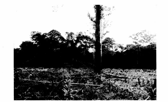
(a) (i) What evidence shows that this is a ground general-view photograph? (2 marks)
(ii) Draw a rectangle measuring 12 cm by 8 cm. (1 mark)
(iii) On the rectangle, sketch and label the following features shown on the photograph:
I planted crops (1 mark)
– tree stumps (1 mark)
~ forest (1 mark)
‘ felled trees (1 mark)
– the sky. (1 mark)
(iv) Describe the characteristics of the forest shown on the photograph. (5 marks)
(b) Explain four measures being taken by the Government of Kenya to control human encroachment on forested areas. (8 marks)
(c) Give the differences between softwood forests in Kenya and Canada under the following sub headings:
(i) tree harvesting (2 marks)
(ii) marketing of forest products. (2 marks)
7 Use the map below to answer question a(i) and (ii).
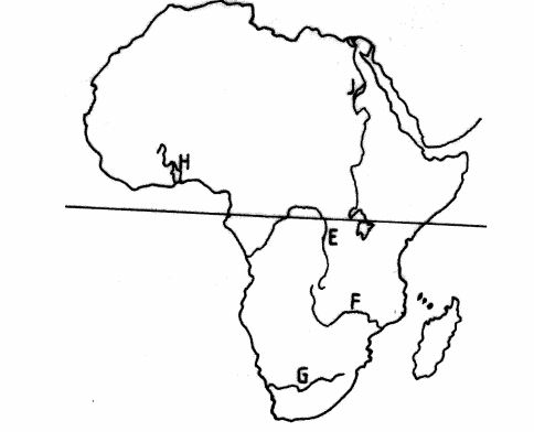
Name
(a) (i) The rivets marked E, F and G. (3 marks)
(ii) The human-made lakes marked H and J. (2 marks)
(iii) Explain four measures which should be taken to improve inland water transport in Africa. (8 marks)
(b) State four ways in which communication contributes to economic development in Kenya. (4 marks)
(c) Explain four problems facing railway transport in Africa. (8 marks)
8 (a) (i) Give four factors common to Kenya and the Netherlands that have favoured horticultural farming. (4 marks)
(ii) State three features of horticultural fanning in the Netherlands, (3 marks)
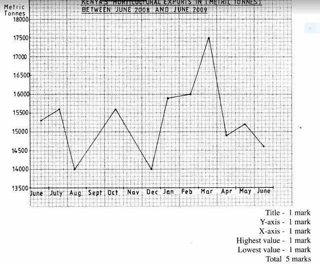
(b) The table below shows the quantity and value of Kenya’s horticultural exports between June 2008 and June 2009. Use it to answer question (b).
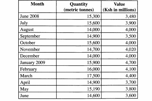
(i) What was Kenya’s total value of exports from horticulture between June 2008 and June 2009? ~ (2 marks)
(ii) Comment on the trend of the quantity of Kenya’s horticultural exports between June 2008 and June 2009. (3 marks)
(iii) Using the data provided, draw a simple line graph to represent the quantity of Kenya’s horticultural exports. (5 marks)
Use a vertical scale of 1 cm to represent 500 metric tonnes.
(c) Explain four difficulties that farmers in Kenya experience in marketing horticultural produce.(8 marks)
9 (a) What is eco-tourism?(2 marks)
(i) Give four tourist attractions found at the coast of Kenya.(4 marks)
(ii) State five problems associated with tourism in Kenya.(5 marks)
(c) State four ways in which game reserves are of benefit to the communities living near them. (4 marks)
(d) Explain the differences between tourism in Kenya and Switzerland. (10 marks)
10 (a) Differentiate between a rural settlement and an urban center. (2 marks)
(b) Explain how the following physical factors influence human settlement:
(i) relief (6 marks)
(ii) climate. (4 marks)
(c) Explain the causes of the following problems in urban centres in Kenya: (i) traffic congestion (4 marks)
(ii) environmental degradation. (4 marks)
(d) (i) Name two towns in Kenya that started as agricultural collection centres. (2 marks)
(ii) Give three social functions of Kisumu town. (3 marks)
2011 KCSE Geography Past Paper-Marking Scheme/Answers
1 (a) The diagram below shows the angles of the sun’s rays at different latitudes when the sun is at the equator. Use it to answer questions (a) and (b).
K
(a) Name the parts of the earth’s surface marked J and K
J – North pole
K – South pole
(2 marks)
(b) Give two reasons why the intensity of the insolation is higher at M than at N There is a higher concentration of heating at M than at N because the surface area at M is small than at N.
The angle of incidence of the sun’s rays at M is higher than at N have the variation in intensity.
At N the sun’s rays travel over a longer distance than at M thus losing the heat resulting to low intensity.
Any 2 x 1:2 marks
2 (a) What is weathering?
Weathering is the breaking down/disintegration and decomposition of rocks at or near the earth’s surface in situ by physical or chemical process.
(2 marks)
(b) Give three factors that influence the rate of weathering.
Climate
Nature of the rock
Topography/angle of slope/slope
Living organisms (flora and fauna)
Human activities
Time.
Any 3 x 1=3 marks
3 Diagram of a composite volcano (see question paper)
(a) Name the features marked P, Q and R
P – Crater
Q – Lava layers
R – Dyke/slide/vent
(3 marks)
(b) How is a parasitic cone formed?
Pressure is reduced causing the magma from the interior of the earth to fail to reach the top of the volcano.
The upper part of the main vent of the volcano is blocked.
Pressure builds up and the magma escapes through a side vent.
The successive outpoutings of magma through the side vent builds alternative layers of ash and lava.
The layers of ash and lava form a conelet on the side of the composite volcano. The conelet is the parasitic cone.
Any 3 x 1=3 marks
4 (a) What is land breeze?
It is a mass of cool air blowing from the land to the sea during the night. (2 marks)
(b) Give two ways in which sea breezes influence the adjacent land
It lowers temperature of adjacent areas.
It may increase rainfall.
It may increase relative humidity.
It moderates diurnal range of temperature.
It may lead to convectional rainfall.
Any 2 x 1 = 2 marks
Name the three ways labelled E, F and G.
E – Traction/surface creep
F – Saltation
G – Suspension
(3 marks)
(b) Name three features produced by wind abrasion in arid areas
Rock pedestal
Zeugens
Yardangs
Venitifacts/dreikanters/Einkanter
Mushroom blocks/Gours
Millet seed/sand grains.
Any,3 x 1 = 3 marks
6 Map of Nkubu (provided)
(a) (i) Latitude — 0° O0’ and Longitude – 37°45 ‘E or
O’00’, 37°45’E
2 marks
(ii) Methods used to represent relief
Contours
Trigonometrical stations
Depression symbols.
Any 2 x 1= 2 marks
(iii) Relief feature found at the top of Kirui Hill
Depression
1 mark
(iv) Apart from administration, give three other services that are provided at Nkubu Divisional Headquarters
Medical services
Educational services
Commercial services
Religious services
Communication.
Transportation
Rehabilitation
Any 3 x 1=3 marks
(b) (i) Length in kilometres of all-weather road bound surface from the bridge at ” Nkubu water works (509935) to Gatimbi road junction (509995).
7.0 1 0.1 (6.9 – 7.1) Km.
(2 marks)
State three problems that may be encountered during construction of roads in the area covered by the map.
(ii) The rugged relief/steep/slopes/many hills which may necessitate road cuttings/many road bends.
Many rivers/river valleys may lead to the constnlction of many bridges/culverts.
The high density of settlement may lead to high cost of compensation.
The presence of Rurie swamp/swamps may lead to detouring of roads/tracks.
Any 3 x 1=3 marks
(c) Citing evidence from the map, give three reasons why cattle rearing is widespread in Nkubu area.
The presence of scrub and scattered trees show that there is natural pasture for cattle.
The presence of many rivers/sources of water show that there is adequate water for cattle.
The area has high altitude evidence /above 1000M which provides cool conditions suitable for cattle rearing.
The many cattle dips for treatment of cattle show that there is access to veterinary services.
Availability of extension services to the farmers as shown by Farmers Training Centre.
Large tracts of land with few settlements to the South East ensuring extensive area available for grazing..
Dense settlements to provide market for cattle/cattle products.
Availability of transport as shown by the roads/tracks for movement of cattle/cattle products.
Any 3 x 2=6 marks
(d) Describe the drainage of the area covered by the map
The main drainage feature are rivers.
The other drainage features are lakes and seasonal swamps.
There is a high density of/many rivers in the area.
The rivers are permanent.
Most rivers originate from Mt. Kenya forest.
Most rivers from the forest flow Eastwards.
Most rivers form a dentritic pattem.
The main rivers are Kithinu and Thingithu.
Most rivers are in the youthful stage.
Some rivers are bending/winding.
Any 6 x 1= 6 marks
7 (a) (i) State three conditions that are necessary for siting a weather station.
The area should be away from buildings/trees/tal objects.
The ground should be free from flooding.
The area should have a wide view/open space.
The area should be secure.
The ground should be gentle sloping
Any 3 x 1= 3 marks
(ii) Give four reasons why weather forecasting is important
It enables farmers to plan their farming activities.
It helps people to choose the clothing for the day.
It influences design of houses.
It guides in the timing of sporting/tourist activities.
It helps in averting natural disasters related to Weather.
It guides in landing and taking off of aircraft.
It helps in planning military activities.
It guides fishing activities.
Any 4 x 1= 4 marks
Table – See question paper
(i) The mean – 16.1°C
(2 marks)
(ii) Annual range of temperature – 2.l°C (2 marks)
BAR GRAPH PRESENTING/SHOWING RAINFALL FOR A STATION
(C) (i)
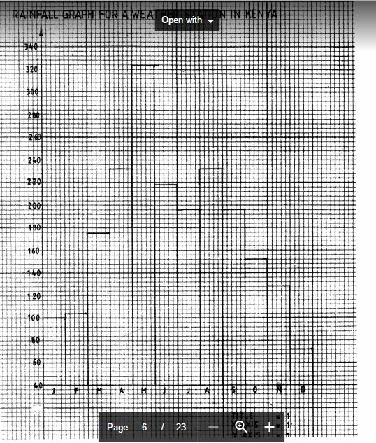
(c) (ii) Describe the characteristics of the climate experienced at the weather station. The climate conditions are generally cool.
The station receives high rainfall/2125mm.
The lowest rainfall (71 mm) is received in December /the highest rainfall (323 mm) is received in May.
The temperature ranges from 15.0° in August to 17.1°C in March/Apn1./ The annual range of temperature is small /(2.l°C).
The area is wet receives rainfall throughout the year. /there is no dry month.
Any 3 x 1=3 marks (d) Suppose you visited a weather station for a field study on weather;
.j (i) Give three methods you would use to collect data:
– Observation
– Interviewing
– Reading from secondary sources
– Administering/filling in questionnaires
– Taking measurements eg. rainfall
– Reading instruments (Thermometer)
– Filming/video taping/taking photographs.
Any 3 x 1=3 marks
(ii) State three advantages of studying weather through fieldwork
It enables students to collect first hand information.
It helps students to develop manipulative skills.
It enables students to learn how to make weather recording instruments.
It enables students to apply the knowledge learned in the classroom.
It makes learning interesting.
It makes learning real
It provides detailed/in-depth/broader learning.
It enhances visual memory
Any 3 x 1 = 3 mark
8 (a)
P – Andes
Q – Appalachians
R – Atlas
S – Himalayas.
Any 4 x 1 = 4 marks
(b) (i) Apart from fold mountains, name three other features resulting from folding
– Synclinal valleys/depressions
— Rolling plains
– Ridges
– Intermontane basins
– Intermontane plateaus
Any 3 x 1=3 marks
(ii) With a well labelled diagram describe how fold mountains are formed.
Extensive shallow depressions called geosynclines develop on the earth’s surface.
Prolonged and extensive erosion occurs on the surrounding higher grounds.
Sediments are deposited in the geosyncline forming thick layers.
The weight of the sediments causes subsidence of the geosyncline leading to accumulation of more sediments to great thicknesses.
Further subsidence of the geosyncline triggers off compressional forces which cause the sediments to fold.
The folded layers of sediments in the geocyncline are thrust upwards to form fold mountains, along the edges of a geosyncline due to closeness to the source of forces.
Diagram = 3 marks
Test = 5 marks
(c) Explain the significance of fold mountains to human activities
Fold mountains are sources of rivers that provide water for generation of H.E.P /domestic use/irrigation/industrial use.
Fold mountains are often forested and provide timber which is used in the building and construction industry/medicinal/aesthetic/wildlife habitat.
Some fold mountains have exposed valuable minerals deposits which are mined.
/f Fold mountains are tourist attractions/snow covered slopes encourage sporting activities, thus earning countries foreign exchange.
The wind ward slopes of fold mountains receive heavy precipitation which enhances agricultural activities.
The rugged nature of some fold mountain landscapes hinder human settlement/agricultural activities.
The leeward slope of some fold mountains create rain shadow effect which result into aridity discouraging crop farming/encourages livestock farming.
Some fold mountains may act as barrier to transport and communication/make the construction of transport and communication lines difficult/expensive.
~ Any 4 x 2=8 marks
9 (a) (i) What are tides?
Tides are the periodic rise and fall in the level of ocean/seas/large lakes as a result of the gravitational attraction of the sun and moon.
2 marks
(ii) Give three causes of ocean currents.
Differences in ocean water density/salinity.
Differences in ocean water temperature.
Winds blowing over the ocean.
Shape of coastal land mass.
Rotation of the earth
Any 3 x 1=3 marks
(iii) Name the three ocean currents along the western coast of Africa Benguela Guinea Cannary. 3 x 1 = 3 marks (b) (i) State three characteristics of submerged lowland coasts.
The coasts have broad shallow indentation/estuaries
The coasts have several creeks.
The coasts have extensive marshes/mudflats exposed at low tides.
The coasts have gentle slopes.
Broad continental shelf
Any 3 x 1=3 marks
(ii) Explain three factors that determine the rate of coastal erosion.
The duration of exposure of the coast to wave erosion. The longer the exposure to coastal waves, the higher the rate of erosion.
The degree of exposure of the coast to wave erosion. The exposed coasts are eroded more than the sheltered coasts that are sheltered hence reducing the rate of erosion.
The nature/supply of material. Heavy materials/builders have a higher erosive power than fine materials.
The nature/structure of the coastal rock. A coast made up of soft rocks wears away easily when subjected to sea waves/when rocks are well jointed/fractures/unconsolidated are weak soluble composed of limestone/ are easily eroded.
The nature/strength of the destructive waves. Strong waves will cause greater erosion by hydrantic action and erosion process.
Any 3 x 2:6 marks
(c) With the aid of labelled diagrams, describe the process through which a stack is formed Waves attack both sides of a headland at right angle.
The Waves erode through abrasion and hydraulic actions forming caves on both sides of the headland.
Continued wave erosion and weathering leads to the elongation of the caves into headland. Eventually the caves merge leading to formation of an arch.
The roof of the arch collapses leading to isolation of part of the headland on the seaward side.
The isolated headland is the stack.
Diagrams = 4 marks Text = 4 marks 8 marks
10 (a) (i) What is a lake?
A lake is an extensive body of Water in a hollow/depression in the earth’s surface.
2 marks
(ii) Name two crater lakes in Kenya
Challa
Paradise
Simbi
Sonanchi (SW of Lake Naivasha)
Crater lake on the Central Island of Lake Turkana.
Any 2 x 1 = 2 marks
(b) Describe how the following lakes are formed.
(i) Corrie lake
Snow accumulates in an existing depression on the mountain side.
Snow gets compacted into ice forming a cirque glacier.
Frost action/alternating freeze-thaw action enlarges the hollow.
Abrasion by ice will deepen the hollow.
Plucking process steepens the backwall.
Eventually a deep arm-chair shaped depression known as corrie is formed.
When the corrie fills up with melt water, it forms a corrie lake.
Any 4 x 1 =4 marks
(ii) Oasis
A pre-existing depression formed through faulting or otherwise is exposed to wind erosion.
Wind eddies remove unconsolidated materials through deflation.
Wind abrasion deepens and widens/enlarges the depression.
Continued deflation deepens and enlarges the depression.
Further abrasion deflation leads to the depression reaching the water table.
Water oozes out of the ground and collects into the depression to form a lake known as an oasis.
Any 4 X 1= 4 marks
(iii) Lagoon
Sand/single are moved by the long shore drift and deposited at the entrance of the bay.
The deposits accumulate forming a spit/sand bar/ridge.
The continued deposition elongate the spit, eventually blocking the mouth of the bay forming a bay bar.
The bay bar separates part of the sea water from the open sea.
The enclosed sea water is the lagoon.
Any 4 x 1 =4 marks
(c) (i) Give three reasons why some lakes in Kenya have saline water.
They lack outlets to the sea.
Some have salt bearing rocks on the lake bed.
High temperatures in the surrounding area lead to high evaporation.
Heavy deposition of mineral salts into the lakes by surface run off.
Underground seepage of water that is rich in mineral salts.
Any 3 x 1= 3 marks
(ii) Explain how each of the following has affected lakes in Kenya
– Deforestation
It exposes soil which is eroded and carried into the lake causing siltation.
IT destroys catchment areas which reduces water fed into the lakes.
Any 2 x 1 =2 marks
– Industrialization .
Establishment of industries had led to disposal of waste/pollution/contamination of lakes.
Establishment of industries has led to increased water use which has lowered water levels.
Any 1 x 2=2 marks
– Water Needs
When water is diverted into farms during irrigation it leads to lowering water levels in the lake.
Over use of water for industrial processes leads to lowering of water levels in the lakes Any 2=2 marks
14.2 Geography Paper 2 (312/2)
1 (a) Name two exotic breeds of commercial beef cattle reared in Kenya.
~ Aberdeen Angus
~ Hereford
‘ Galloway
‘ Charolais
‘ Shorthorn
‘ Sahiwal
Any 2 x 1=2 marks
(b) Outline two similarities of commercial beef cattle fanning in Kenya and Argentina.
~ In both countries the cattle are mainly reared in areas of natural grazing/natural pasture.
‘ In both countries crossbreeding of beef cattle is common/scientific method of production.
– In both countries beef cattle are reared mainly in ranches.
‘ In both countries beef cattle/products are meant for the local and foreign market. ‘ In both countries cattle breeds are largely similar. Any 2 x 1=2 marks
2 (a) Define the term fisheries.
– Fisheries are water bodies where aquatic organisms/fish are found/reared for exploitations. 2 marks
(b) State three ways in which marine fisheries in Kenya can be conserved.
~ Restocking the over fished areas.
‘ Standardizing the mesh size of nets to be used in fishing
‘ Licencing commercial fishermen to control their numbers.
‘ Restricting fishing to specific seasons.
~ Restricting the disposal of untreated waste into the sea/control of water pollution.
‘ Monitoring and discouraging the entry of foreign fishermen off the Indian Ocean waters.
‘ Enforcing the International conventions to protect endangered fish species.
Any 3 x 1= 3 marks
3 (a) Name two prairie provinces of Canada where wheat is grown on a large scale.
~ Saskacthewan
~ Alberta
~ Manitoba
Any 2 x 1=2 marks
(b) Give three physical conditions that favour large scale wheat farming in the prairie provinces of Canada.
‘ There is extensive (cheap) land that allows cultivation on a large scale.
– The presence of fertile prairies soils/dark brown chemozems .
– The undulating landscape allows use of farm machinery/mechanization ‘ There is suitable climate with a frost-free period/warm sunny 15 – 19° which allows for timely ripening and harvesting.
‘ The area receives moderate rainfall/average 560mm annually which is suitable for wheat growing.
Any 3 x 1=3 marks
4 (a) State three reasons Why paper milling industries are located near rivers.
~ The industries need large amount of water for cleaning.
‘ The industries use water for cooling machines.
‘ The industries dispose off their waste materials through water.
‘ Water provide cheap means of transport.
‘ Some industries are located near large rivers that may provide H.E.P.
~ Water is used as raw material in the industries.
– Some industries use water to debark the logs.
Any 3 x 1 = 3 marks
(b) Name three industries in Kenya that use agricultural non-food products as raw materials.
‘ Tobacco processing.
‘ pyrethrum processing.
~ Plant fibre processing.
‘ Saw milling ./Textile industries
‘ Paper making.
‘ Leather tanning.
~ Pharmaceuticals industries
‘ Glue making industry
‘ Rubber based industry.
– Footwear industry
‘ Non-edible oil processing.
Any 3 x 1=3 marks
5 (a) State three measures which the government of Kenya has taken to reduce infant mortality.
‘ There has been widespread immunization for children to control diseases.
~ The government provides free medical services for children/Free mosquito nets.
‘ The government provides parental education to ensure better care for children breast-feeding campaigns/Family planning.
– There is a government policy granting longer maternity leave for mothers/paternity leave to take care of the new born.
‘ Research on infant related diseases has been stepped up.
– The government encourages provision of homes for orphans.
‘ Training of traditional mid-Wives.
~ The govemment has improved/increased medical facilities.
Any 3 x 1=3 marks
(b) Give two negative effects of low population growth in a country.
– It leads to under utilization of resources/slow economic growth ‘ It leads to reduced market for goods.
‘ Increased ageing population in a country leads to high dependency.
‘ It leads to reduced labor force/productivity.
‘ It is expensive to provide social security/medical care/transport.
Any 2 x 1= 2 marks
6 Study the photograph below and use it to answer question (a)
(a) (i) What evidence shows that this is a ground general-view photograph?
~ The photograph captures the broad view of area/a broad view of the area is captured.
– The focus is on many objects
‘ The objects become progressively smaller towards the background.
Any 2 x 1 = 2 marks
(ii) Draw a rectangle measuring 12 cm by 8 cm (1 mark)
(iii) On the rectangle, sketch and label the following features shown on the photograph:
‘ planted crops (1 mark)
‘ tree stumps (1 mark)
– forest. (1 mark)
~ felled trees. (1 mark)
– the sky. (1 mark)
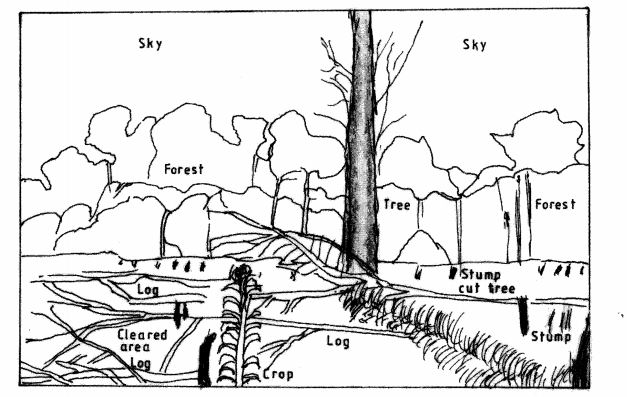
(iv) Describe the characteristics of the forest shown on the photograph.
‘ The forest has tall trees.
‘ The trees have straight stems.
‘ The forest has some shrubs/undergrowth.
v Some trees have thin stems.
‘ The trees are close to each other./dense forest
‘ The trees form different layers/canopies.
‘ Some trees are umbrella shaped.
‘ The forest is natural.
~ he forest has mixed species
Any 5 X 1: 5 marks
(b) Explain four measures being taken by the government of Kenya to control human encroachment on forested areas.
‘ Gazettement of forested areas to delimit the areas and reduce encroachment by the public.
~ Evicting people who have encroached forested areas in order to rehabilitate the forests.
~ Educating the public/creating awareness on the importance of conserving forests to gain their support.
‘ Enacting/enforcing laws to prohibit cutting of trees within the gazetted areas.
– Employing forest guards to patrol forest reserves to ensure that illegal activities are reported.
‘ Encouraging people to use other sources of energy in order to reduce the demand for wood fuel.
‘ Fencing off forested areas/maintaining buffer zones to keep away any intruders into the forest.
1 Encouraging people to practice agro-forestry to avoid dependence on products from the forests.
Any 4 x 2=8 marks
(c) Give the differences between softwood and forests in Kenya and Canada under the following sub headings:
(i) Tree harvesting.
~ In Kenya harvesting of trees is done throughout the year while in Canada harvesting is done in winter and early spring.
‘ In Kenya harvesting is done selectively while in Canada clear/indiscriminate cutting of trees is done.
Any 1 x 2=2 marks
(ii) Marketing of forest products.
In Kenya forest products are mainly sold locally Whereas forest products in Canada are mainly exported.
Any 2=2 marks
Use the map below to answer question a(i) and (ii).
(a) Name
(i) The rivers marked E, F and G.
‘ E – R. Congo.
‘ F – R. Zambezi.
‘ G – R. Orange.
3 x 1 = 3 marks
(ii) The human-made lakes marked H and J .
‘ H – Kainji
‘ J – Nasser
Any 2 x 1 = 2 marks
(iii) Explain four measures which should be taken to improve inland water transport in Africa.
– The waterways should be dredged regularly to control siltation/maintain constant depth of the rivers and lakes for easier navigation.
~ Dams/barrages should be constructed to control flooding hence allowing navigation.
‘ Constructing canals/canalizing the rivers where waterfalls, rapids or rock outcrops exist to bypass obstacles that hinder navigation.
‘ Constant clearing/controlling the growth of vegetation to allow free movement of vessels.
‘ Using modern vessels and equipment to improve the efficiency of handling cargo/passenger service.
– Removal of rock obstacles from river beds to allow free navigation.
Any 4 x 2=8 marks
(b) State four ways in which communication contributes to economic development in Kenya.
‘ Technological efficiency in communication makes business transactions easier/faster.
‘ Modern communication network allow for the spread of ideas/information for decision making which enhances economic development.
‘ Communication promotes development of related industries/business opportunities. ‘ Communication services provide employment opportunities.
‘ Communication connectivity promotes mobility of labour.
~ Individuals/Companies/Government earn income /derives revenue from communication services.
‘ Communication facilitates marketing of products thus a wider market
Any 4 x 1 =4 marks
(c) Explain four problems facing railway transport in Africa.
‘ African countries use different railway gauges which makes it difficult to have an integrated railway transport system/transhipment of goods.
0 Construction of railways require large amounts of capital that most countries lack, either to extend or maintain the existing lines.
* Accidents/vandalism/uprooting of the railway line causes great losses/delays in transportation.
~ Tropical storm waters at time wash away vital sections of the railway lines thereby disrupting transport/causes accidents .
~ Railway transport faces stiff competition from the faster/flexible means of transport such as road and air transport hence under-utilization of railway facilities.
~ Fuelling/maintenance of railway stations and other related overhead costs are high thus reducing profit margins.
Any 4 x 2=8 marks
8 (a) (i) Give four factors common to Kenya and the Netherlands that have favored horticultural fanning.
‘ Both countries have a varied of climatic conditions.
~ In both countries horticultural farming is practiced in areas with well drained soils.
~ In both countries irrigation is carried out.
‘ Both countries sell their horticultural produce in the local and international market.
‘ In both countries large companies/private organisation have invested in horticultural farming.
– In both countries green housed are used.
‘ Use of advance technology i both countries.
‘ Availability of labour in both countries.
‘ In both countries transport net work in developed.
Any 4 x 1 =4 marks
(ii) State three features of horticultural farming in the Netherlands.
~ The farms are generally small in size.
‘ The farmers use advanced/highly specialized techniques of crop production/farmers use .greenhouses.
‘ Most farmers practice mixed fanning.
‘ The farms are intensively used.
~ Farming is largely labour intensive.
Any 3 x 1=3 marks
(b) The table below shows the quantity and value of Kenya’s horticultural exports between June 2008 and June 2009. Use it to answer question (b).
(i) What was Kenya’s total value of exports from horticulture between June 2008 and June 2009?
~ Kshs .51 ,200 Million.
Any 2 x 1 = 2 marks
(ii) Comment on the trend of the quantity of Kenya’s horticultural exports between June 2008 and June 2009.
~ The quantities of exports are fluctuating.
– The lowest exports were in August 2008 and December 2008.
‘ The highest quantity of export was in March 2009.
– There was a significant drop in the quantity of exports between March and April 2009.
Any 3 x 1 = 3 marks
(iii) Using the data provided, draw a simple line graph to represent the quantity of Kenya’s horticultural export.
Use a vertical scale of 1cm to represent 500 metric tonnes.
(c) Explain four difficulties that farmers in Kenya experience in marketing horticultural produce.
The impassable roads during the rainy season/poor road network make it difficult for the perishable produce to reach the market on time, hence causing losses to the farmers.
The cost of transporting produce by air is high thus lowering the profit margin.
Poor marketing strategy leads to reliance on middlemen who exploit the farmers/farmers incur losses.
Low quality produce may lead to rejection in the market hence making the farmers incur losses/farmers are demoralised.
The farmers face stiff competition from the established and upcoming producers which limits the quantity the farmers are able to sell.
Stringent quality standards required at the international market increases the cost of production thus lowering the profit margin.
Fluctuations of the world market prices cause inconsistencies in the profits margin thus discouraging the farmers.
Limited preservation facilities/refrigeration facilities leads to the spoilage of the produce hence losses/wastage.
Any 4 x 2 = 8 marks
9 (a) What is eco-tourism?
‘ It is the development and management of tourism while conserving the environment/enjoy- ing what nature provides while protecting it.
2 marks
(b) (i) Give four tourist attractions found at the Coast of Kenya.
‘ Marine parks.
‘ Historical sites.
‘ Sandy beaches/coral reefs/coastal scenery.
~ Sunny/warm climate.
~ Traditional culture.
‘ Water sports/beach sports.
‘ Wildlife.
Any 4 x 1: 4 marks
(ii) State five problems associated with tourism in Kenya.
‘ Tourism has led to increase in drug abuse.
‘ A number of youths especially at the Coast have dropped out of school to become tour guides/beach boys/sex workers/curio sellers.
‘ Tourism has led to the spread of diseases such as S.T.ls.
– Tourism has led to pollution of environment/National parks/ game reserves.
‘ Over emphasis on tourism has led to the neglect of the other sectors of economy.
‘ Tourism has led to increase in crime/insecurity.
‘ Tourism has encouraged poaching/illegal collection of marine resources.
‘ Tourism has led to international terrorism/piracy.
‘ Erosion of some social value/culture.
Any 5 X 1 = 5 marks
(C) State four ways in which game reserves are of benefits to the communities living near them.
– The game reserves offer employment opportunities to the communities living near them.
‘ The management of the game reserves provide social amenities to the communities.
– The communities are allowed to graze their animals in the game reserves.
v Access roads to the game reserves benefit the communities.
‘ The income earned from the game reserves by the local authorities is used to provide services to the communities.
‘ Sometimes members of the community are given meat when animals have been culled.
‘ Educational institutions located near the game reserves have easy access for educational tours.
* Increase market for local products.
Any 4 x 1 =4 marks
(d) Explain the differences between tourism in Kenya and Switzerland.
– In Kenya animals are found in their natural habitants while in Switzerland they are found in zoos.
‘ Kenya has tropical climate which is W3III1 and sunny most of the year encouraging sun-bathing while Switzerland has temperate climate with cold winters which encourage winter sports.
‘ Kenya has varied and beautiful Coastal scenery/Rift Valley/ volcanic mountains while Switzerland has varied scenery consisting of snow-capped mountains/ glaciated landscape.
‘ Kenya being far from Europe, gets fewer tourists than Switzerland which is centrally located in Europe.
‘ Kenya’s reports of insecurity scare away potential tourists but the reports of peaceful atmosphere in Switzerland encourage more tourists.
~ Kenya has poorly maintained transport network making it difficult to access some tourist sites while in Switzerland transport network is efficient.
‘ Kenyans are able to speak a few international languages hence communication with the tourists is sometime limited, whereas the diversity of languages spoken in Switzerland make it possible for tourists to communicate with ease.
‘ The training of personnel in tourism industry in Switzerland is more advanced than in Kenya, thus enabling the personnel to provide higher quality services to the tourists.
‘ The accessibility to financial facilities and services such as the use of credit cards, by the tourists in Kenya is limited to large Lu’ban areas, whereas in Switzerland similar facilities and services are widespread promoting easy transactions by tourists.
~ Kenyan’s low purchasing power limits their ability to travel as tourists while in Switzerland the high purchasing power enables people to travel as tourists.
‘ Kenya has coastal beaches while Switzerland has lake side beaches.
Any 5 x 2 =10 marks
(a) Differentiate between a rural settlement and an urban centre.
– A rural settlement consists of villages/scattered homesteads in the countryside where people engage mainly in agricultural activities/primary economic activities, while an urban centre is an area with dense population and people engaged mainly in industrial/ commer- cial activities.
2 marks
(b) Explain how the following physical factors influence human settlement.
(i) Relief.
~ Gentle slopes/lowlands are densely settled, because they are conducive to agriculture/build- ing houses/building roads.
‘ Steep slopes are sparsely settled because they have thin soils making then unsuitable for fanning/building of roads.
~ High mountain tops are not settled because they are too cold for plant growth/human habi- tation.
– Mountaineous areas are thinly settled because of their steep/rugged nature makes them inaccessible.
‘ The leeward side of mountains are sparsely settled because they are dry and limits agricul- tural activities/inadequate water supply/windward side are densely settled because they are wet and encourage agricultural activities/plenty supply of water..
~ Some hills have dense settlements because they are sage and secure.
~ Flat areas/flood plains are sparsely settled due to poor drainage/high incidents of water- borne diseases.
Any 3 x 2=6 marks
(ii) Climate.
‘ Areas that receive high rainfall have dense settlements because they are conducive to a variety of agricultural activities.
‘ Areas with low rainfall are sparsely settled because the climate limits economic activities.
‘ Areas prone to strong winds are often not settled to avoid destruction of property by the wind.
~ Some valley bottoms have more settlements because they are warmer than the higher slopes of mountains.
~ Areas with extreme temperatures discourage settlements because of the unpleasant condi- tions.
Low to high temperatures/cool to hot conditions encourage dense settlement because they are conducive to human habitation/Agricultural activities.
Any 2 X 2=4 marks
(c) Explain the causes of the following problems in urban centres in Kenya. (i) Traffic congestion.
The concentration of administrative/commercial/educational functions activities in the CBD leads to movement of large numbers of people to and from the CBD especially during the rush hour.
The nairowness/presence of roundabouts/poor state of roads of the streets makes the move- ment of traffic around and out of the urban centres slow.
The increase in the number of commuters/vehicles that flock in the mornings and evenings has outstripped the capacity of the existing space.
Similar working schedules for most employees cause workers to report and leave work places at the same time, leading to congestion.
Failure by motorists/pedestrians to comply with traffic rules interferes with smooth flow of traffic.
Any 2 X 2 = 4 marks
(ii) Environmental degradation.
The smoke/exhaust fumes from factories, cars and residential houses cause air pollution/ smog over the urban centres.
Careless disposal of effluents from factories and residential areas into water resources lead to water pollution.
Careless disposal/non – collection of garbage cause land pollution.
The construction of buildings/factories lead to destruction of the landscape.
Careless disposal of waste materials from construction sites leads to tip-heaps that degrade the environment.
Loud noise from industries/vehicles/aircrafts/music cause sound pollution.
Any 2 x 2=4 marks
(d) (i) Name two towns in Kenya that started as agricultural collection centres.
~ Nakuru
– Eldoret
‘ N anyuki ~ Kitale.
‘ Nyeri
‘ Nyahururu
Any 2 x 1 = 2 marks
(ii) Give three social functions of Kisumu town.
‘ Educational centre.
‘ Religious centre.
Residential centre.
‘ Cultural centre.
~ Recreational centre.
Medical centre.
Any 3 x 1 = 3 marks
