
2013 KCSE Geography Past Paper
4.2.1 Geography Paper 1 (312/1)
SECTION A
Answer ALL the questions in this section.
1. a) The diagram below represents the structure of the atmosphere. Use it to answer question (a).
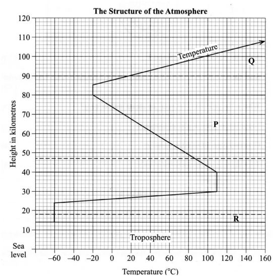
a) Name
(i) the parts marked P and Q. (2 marks)
(ii) the layer of discontinuity marked R. (1 mark)
b) State two characteristics of the weather conditions in the troposphere. (2 marks)
2. State five factors that influence mass wasting. (5 marks)
3. The diagram below shows a section of a river. Use it to answer the questions that follow.
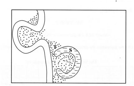
(a) Name the features marked S and T. (2 marks)
(b) State three conditions that are necessary for the formation of the feature marked S. (3 marks)
(a) What is the difference between ice sheets and ice berg? (2 marks)
(b) Name three types of glacial moraines. (3 marks)
(a) Give two types of soil degeneration. (2 marks)
(b) State three economic benefits of soils. (3 marks)
SECTION B
Answer question 6 and any other TWO questions from this section. Study the map of Karatina l:50,000 (sheet 121/3) provided and answer the following questions
(a) (i) What is the four figure grid reference of the Technical Institute at Mathira? (2 marks)
(ii) What is the bearing of Mount Kenya Campus at grid reference 932568 from the cattle dip at grid reference 990529? (2 marks)
(iii) Measure the distance of the railway line from the Level Crossing at grid square 8652 to the Southem edge of the map. Give your answer in kilometres. (2 marks)
(b) Draw a rectangle measuring 15 cm by lO.cm to represent the area enclosed by Eastings 90 and 100 and Northing 50 and 60. (1 mark)
b) On the rectangle mark and name the following:
(i) Kirinyaga District;
(ii) All Weather Road Bound Surface;
(iii) Forest;
(iv) Coffee factory.
(4 marks)
c) Describe the distribution of the natural vegetation in the area covered by the map. (6 marks)
d) Identify two social functions of Karatina town. (2 marks)
e) Citing evidence from the map, explain three factors that favour trading in the area covered by the map. (6 marks)
7 a) Name the first two planets of the solar system. (2 marks)
b) Explain the origin of the earth according to the Nebula Cloud Theory. (8 marks)
I the continent marked W; (1 mark)
II the ocean marked X; (1 mark)
IH the line of longitude marked Y. (1 mark)
(ii) Give two reasons why the earth has a spherical shape. (4 marks)
(iii) State four effects of the rotation of the earth on its axis. (4 marks)
c) Describe the structure of the earth’s crust.
8. a) What is volcanicity?
b) (i) Apart from a sill, name three other intrusive volcanic features. (3 marks)
(ii) Describe how the following features are formed:
c) Explain four negative effects of earthquakes.
9. a) What is vegetation?
I a sill; (3 marks)
H hot springs; (5 marks)
III a caldera. (4 marks)
b) Explain how the following factors influence the distribution of vegetation:
(i)Relief
(ii) soils.
c) Describe the characteristics of the savanna vegetation region. relief (2 marks)
d) You are planning to carry out a field study in a forest.
i. Give four reasons why it is important to seek pemiission from the school administration. (4 marks)
ii. List three sources of information you are likely to use before the actual field study. (3 marks)
iii .Identify four challenges you are likely to encounter during the field study. (4 marks)
10. (a) (i) Name two major deserts found in Africa. (2 marks)
The diagram below represents features resulting from wind erosion in a desert. Use it to answer question a(ii).
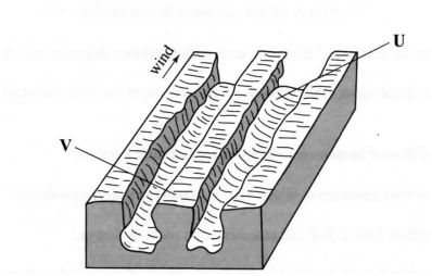
(ii) Name the features marked U and V. (2 marks)
(b) Describe the three processes through which wind transports its load. (6 marks)
(c) Using a well labelled diagram, describe how a barchan is formed. (7 marks)
(d) Explain four ways in which desert features are of significance to human activities. (8 marks)
4.2.2 Geography Paper 2 (312/2)
SECTION A
Answer all the questions in this section.
1 (a) Name the method of irrigation used in the Perkerra irrigation scheme. (1 mark)
(b) State three factors that influenced the location of the Perkerra irrigation scheme. (3 marks)
2 State four effects of human encroachment into wildlife habitats. I (4 marks)
3 (a) Name two countries to which Kenya exports petroleum products. (2 marks)
(b) State four factors that influence extemal trade in Kenya. (4 marks)
4 (a) State two factors that lead to the development of nucleated settlement patterns. (2 marks)
(b) Identify two differences in the functions of Nairobi and New York. (4 marks)
5 Identify five ways that are used to control floods in Kenya. (5 marks)
SECTION B
Answer question 6 and any other two questions from this section. 6 .The table below shows the approximate population size of four districts in Nairobi in the year 2009.
Use it to answer question (a)
Source: Kenya National Bureau of Statistics.
(a) (i) Apart from pie charts, name two other statistical methods that can be used to represent the data in the table. (2 marks)
(ii) Using a radius of 5 cm. draw a pie chart to represent the data in the table above. Show your calculations. (9 marks)
(iii) Calculate the population growth rate of Nairobi over the 10 year period if the populations was approximately 2,143,000 in 1999. (2 marks)
(b) Explain two factors that may have led to the large population increase in Nairobi between 1999 and 2009. (4 marks)
(c) Explain four positive effects of low population growth in a country. (8 marks)
7. The map below shows the location of some minerals in East Africa.
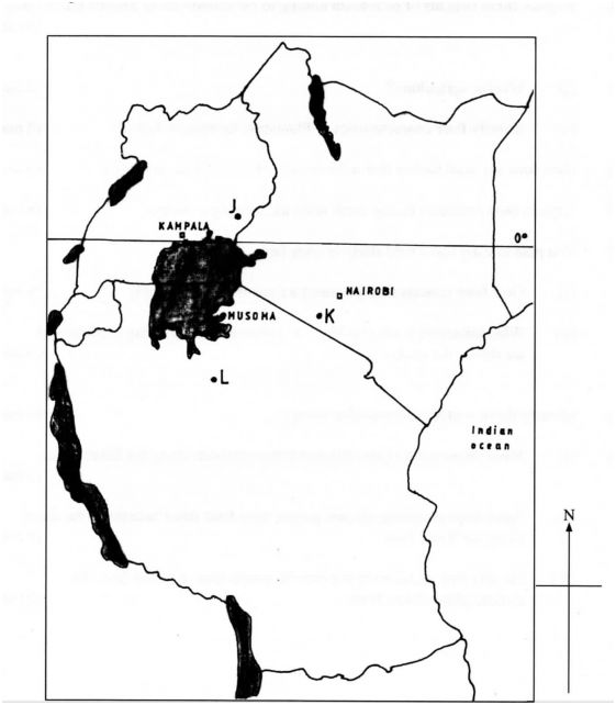
a) Name the minerals mined in the areas marked J , K and L. (3 marks)
b) Explain how the following factors influence the exploitation of minerals:
(i) mode of occurrence of minerals; (4 marks)
(ii) transport; (4 marks)
(iii) level of technology. (4 marks)
c) Describe the opencast method of mining. (4 marks)
d) Explain three benefits of petroleum mining to the economies of Middle East Countries. (6 marks)
8. a) (i) What is agriculture? (2 marks)
(ii) Identify four characteristics of Plantation farming in Kenya. (4 marks)
b) Give four physical factors that influence the growing of tea in Kenya. (4 marks)
c)Explain four problems facing small scale tea farming in Kenya. (8 marks)
d) You plan to carry out a field study in a tea farm.
(i) Give four reasons why you need a route map for the study. (4 marks)
(ii) What information are you likely to gather about marketing of processed tea during the study? (3 marks)
9. a) Identify three sources of renewable energy. (3 marks)
b) (i) Name three main Hydro Electric Power Stations along the River Tana. (3 marks)
(ii) Apart from providing electric power, state four other benefits of the dams along the River Tana. (4 marks)
(iii) Identify two problems that affect the production of power from the stations along River Tana. (2 marks)
(c) Explain four measures the Government of Kenya has taken to conserve energy. (8 marks)
(d) Some students carried out a field study on sources of energy by sampling the households around their school.
(i) Identify two sampling techniques the students may have used during the study. (2 marks)
(ii) Give three advantages of sampling the households for the study. (3 marks)
(a) Differentiate manufacturing industries from tertiary industries. (2 marks)
(b) Explain why the Government of Kenya encourages the setting up of industries in rural areas. (8 marks)
(c) Explain four factors that have contributed to the development of electronics industry in Japan. (8 marks)
(d) You intend to carry out a field study in a nearby post office.
(i) Identify two characteristics of a good hypothesis for the study. (2 marks)
(ii) State three advantages of using the interview method to collect data during the study. (3 marks)
(iii) Give two challenges facing postal services that you are likely to find out during the study. (2 marks)
2013 KCSE Geography Past Paper-Marking Scheme/Answers
5.2.1 Geography Paper 1 (312/1)
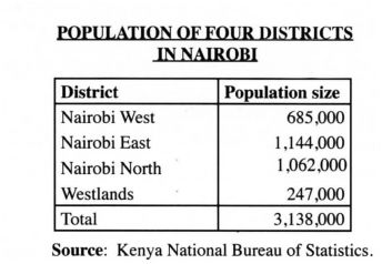
1. The diagram below represents the structure of the atmosphere. Use it to answer question (a)
(a) Name
i V Troposphere
(ii) the pans marked P and Q.
P – Mesosphere _ (1 mark)
Q – Thermosphere/lonosphere (1 mark)
(ii) the layer of discontinuity marked R.
R – Tropopause
(b) State two characteristics of the weather conditions in the troposphere. Temperatures decrease with an increase in height/normal lapse rate / the rate decrease is 1°C for 160 metres of height/0.65°C per 100 m/6.5 per 1000m Pressure falls with an increase in height. The speed of wind increases with an increase in height. It contains most of the atmospheric water vapour/clouds. Any 2×1 = 2marks
2.State five factors that influence mass wasting. Seisrnic/earth quake shocks lead to the movement of materials down slope. Increased overburden/deeply weathered thick/thinnly bedded rock materials are likely to move down slope. Increase in moisture lubricates the soil. Lack of vegetation reduces the ability of the soil to hold together. Under cutting of the slope by excavation/mining/quarrying/construction. Rearrangement of soil particles by living organism in the soil. The angle of slope determines the movement of the material. The nature of the underlying rock.
Any 5 x 1 = 5marks
3. The diagram below shows a section of a river. Use it to answer the questions that follow.
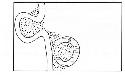
(a) Name the features marked S and T .
S – ox-bow lake (1 mark)
T – alluvial deposits (1 mark
(b) State three conditions that are necessary for the formation of the feature marked S. Presence of pronounced meanders in the flood plain. Heavy load being carried by the river. A reduction in the river gradient/reduction in the river energy to erode vertically/ low velocity. Presence of obstacles in the river channel. Laterial erosion on the outer side of the river banks. Deposition on the inner side of the river banks. Periodic flooding to cut off neck of pronounced meander.
Any 3 x 1 = (3 marks)
4 (a) What is the difference between an ice sheets and an ice berg? Ice sheets is a continuous mass of ice covering vast areas of land while an ice bergs is a large block of ice (broken from ice sheets) floating in seas/oceans. (2 marks)
(b) Name three types of glacial moraines. Laterial moraine Medial moraine Terminal moraine Ground/subglacial moraine Recessional moraine Englacial moraine Push moraine.
Any 3 x 1 = (3 marks)
5 (a) Give two types of soil degeneration. Physical degeneration. Chemical degeneration. Biological degeneration.
Any 2 x 1 = (2 marks)
(b) State three economic benefits of soils. They provide the base for crop/forest cultivation. Some are sources of valuable minerals. They are raw materials for ceramic / pottery / sculpture industries. They are used for building houses / roads / bridges. Organic soils such as peat serve as fuel resource. Salt licks are livestock feeds.
Any 3 x 1 = (3 marks)
SECTION B
Answer question 6 and any other TWO questions from this section.
Study the map of Karatina 1:50.000 (sheet 121/3) provided and answer the following questions.
four figure grid reference of the Technical Institute at Mathira? 8559 (2 marks)
(ii) What is the bearing of Mount Kenya Campus at grid reference 932568 from the cattle dip at grid reference 990529?
304° 1 1° (303° – 305°) _ (2 marks)
(iii) Measure the distance of the railway line from the Level Crossing at grid square 8652 to the Southem edge of the map. Give your answer in kilometres.
13.3km:0.1-(13.2-l3.4km) (2marks)
(b) Draw a rectangle measuring 15 cm by 10 cm to represent the area enclosed by Eastings 90 and 00 and Northing 50 and 60. On the rectangle mark and name the following:
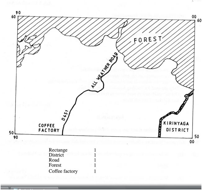
(i) Kirinyaga District;
(ii) All Weather Road Bound Surface;
(iii) Forest;
(iv) Coffee factory.
c) Describe the distribution of the natural vegetation in the area covered by the map. The high altitude / mountain a.rea is covered by thick forest/bamboo. The forest mainly covers the Northem/North Eastern part of the area covered by the map. There is a few patch of forest in the Southern/South Westem part of the area covered by the map. Woodland covers the North West, North/Eastem part of the area covered by the map. There is papyrus swamps vegetation found in the Southem/Southem Eastem part of the area covered by the map. ‘ , There are riverine trees along river Nairobi/Kaduni/Sagana. Scrub vegetation covers the South Westem part of the area covered by the map. Scattered trees cover the West/North Westem part of the area covered by the map.
(NB/. Vegetation type must be located to score)
Any 3 x 2 = (6 marks)
d) Identify two social functions of Karatina town. It is an educational centre. It is a residential centre. It is a religious centre. It is a health centre. Water supply. Electricity supply. It is a security/adrninistration centre. (2 marks)
e) Citing evidence from the map, explain three factors that favour trading in the area covered by the map. The presence of numerous market centres / trading centres / shops which provide opportunities for trading (e .g Karatina, Tumu-Tumu, Kimahuri and Kagumo). The area has a well developed transport network for delivery of goods and services evidenced by all weather roads to Kerugoya, Sagana and Embu. The area is economically productive which provides goods as evidenced by tea/coffee factory, fisheries department/fisheries centre/research/cattle dip/murram pit. There are numerous settlements which suggests availability of markets for the variety of goods and services.
Any 3 x 2 = (6 marks)
7 a) Name the first two planets of the solar system. Mercury (1 mark) Venus (1 mark)
(b) Explain the origin of the earth according to the Nebula Cloud Theory. (8 marks) The explosion of the stars led to the formation of a huge cloud of gases (hydrogen and helium), dust and ice particles. This cloud whirled, cooled and condensed to a disc shape. The gravitational attraction within the materials increased cause the particles to compact. Some particles broke from the edge of the disc and whirled. The compacted particles swirled faster towards the centre of the disc in different directions. As they whirled they cooled or solidified to form the planets. This swirling caused particles to collide losing a little energy at a time. The middle of the spinning disc condensed to form the sun while the material . spinning around condensed into large chunks of materials called planetoids. The planetoids collided and coalesced into large bodies called planets. The earth is one of the planets. The centre of the disc formed the sun.
4 x 2 = 8 marks
Use the map below to answer questions (c)(i)
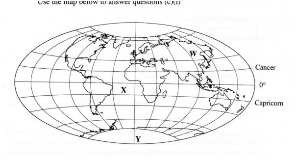
(c) (i) Name:
the continent marked W – Asia.
the ocean marked X – Atlantic.
the line of longitude marked Y – Prime/Greenwich meridian. (3 marks)
(ii) Give two reasons why the earth has a spherical shape. The earth experiences the force of gravity pulling towards the centre which creates a rounding effect on its shape. The North and South poles experience centripetal force which constantly pull towards each other causing the flattening at the poles. At the equator the earth experiences the centrifugal force which causes the bulge.
iii) State four effects of the rotation of the earth on its axis.
Forceh2=2
Shapeh2=2
NB: F can score on its own. “S’ must be tied to “F” to score. It causes the occurrence of day and night /apparent movement of the sun from East to West. ‘ It causes difference in time between places over the earth’s surface. It causes deflection of winds / ocean currents. It causes differences in atmospheric pressure on the surface of the earth. It causes 0cean/sea tides
d)Describe the structure of the earth’s crust. It’s rocks are generally brittle/solid. The earth’s crust extends between 6 to 80 km. It is divided into two layers – sial (continental crust) and sima (oceanic crust). The sial rests on the sima The sial contains mainly silica and aluminium. The sima contains silica, magnesium and iron. The sial is lighter/has a density of 2.65 to 2.70 gm per cc. The sial has mainly granitic rocks. The sima has basaltic rocks. The sima is heavier/has a density of 2.7 to 3.0 g/cc The sima is fairly flexible 8. a) What is volcanicity?
It is the process through which gaseous / liquid / molten rock / solid materials are forced into the earth’s crust and / ejected onto the surface. (2 marks)
b) (i) Apart from a sill, name three other intrusive volcanic features.
Dykes/dikes
Laccolith/laccolites
Batholith/bathyliths
Lopolith
Phacolith/phacolite
Any 3 x 1 = (3 marks)
(ii) Describe how the following features are formed:
I a sill; Below the earth’s crust the rocks are at very high temperature and high pressure. If the pressure becomes less, the hot, solid rock material may become semi-fluid / Magma under high pressure enters crustal rocks. The semi-fluid rock / magma forces itself into horizontal cracksl fissures. The magma cools and solidities in horizontal cracks or bedding plane. This horizontal sheet/layer of igneous rock is called a sill. (3 marks)
II hot springs; Rainwater enters the crustal rocks through cracks / fissures. The water reaches a zone of hot igneous rocks. The water is (super) heated. The super heated water changes into water vapour. The vapour is under high pressure and so forces its way up heating the ground water. The heated water under pressure flows out continuously/to form hot springs. (5 marks)
III A caldera. Lava pouring out of a central vent forms a volcanic cone. The vent may be sealed when lava solidifies in it. The solidified plug block the gases and steam beneath from escaping. There is pilling up of pressure below the plug. The pressure leads to a violent eruption that blows off the top of the cone forming a depression. The resulting large circular depression on the top of the (now lower) volvano is called caldera.
OR
A subsidence caldera Lava pouring out of a central vent forms a volcanic cone. The magma resevoir below the crust is left empty/has a void/cavity. With time the weight of rocks of the volcano exerts pressure on the crustal rocks below. The pressure/earth movements cause cracks to develop making the volcano unstable. Over time the middle portion of the volcano subsides/collapses into the void fomting a depression. The resulting large circular depression on the top of the (now lower) volcano is called caldera.
OR
Outward collapsing Volcanic eruption of ash and cinder/pyroclasts throough a central vent forms a volcanic cone. Several eruptions results to a high, steep and unstable volcano. The weight of the upper materials exerts pressure on the ones beneath causing instability on the lower part. The material at the base begin spreading outwards. The top of the volcano collapses inwards forming a depression. The resulting large circular depression on the top of the volcano is called caldera. (4 marks)
c) Explain four negative effects of earthquakes. Violent motions resulting from earthquakes damage structures from their foundations leading to loss of life and property. When earthquakes occur faults may develop which damages infrastructure. During an earthquake on the sea floor vertical displacement occur leading to development of tsunami leading to floods of coastal areas/disrupts human activities loss of life/property. Earthquakes may lead to landslides which destroy agricultural land/loss of life/ damage of infrastructure.. Strong vibrations from earthquakes may cause damage to nuclear plants which pollute the environment and affect human health. Earthquakes may cause panic/emotional shock/fear. any 4 x 2 = (8 marks)
9. a) What is vegetation?
It is the total mass of plant life that occupies a given area. (2 marks)
Explain how the following factors influence the distribution of vegetation:
(i) relief High altitude areas have low temperature which encourage scanty / no vegetation / low altitude areas have moderate temperature which encourage dense vegetation. Gently sloping areas are well drained hence encouraging dense vegetation growth / steep slopes experience excessive drainage that discourage plant growth. Flat areas tend to be waterlogged hence covered by swampy plant species.
Any 1 x 2 = (2 marks)
(ii) soils. Fertile soils have a variety of nutrients which encourage the growth of dense vegetation/infertile soils have insufficient nutrients leading to scanty vegetation. Medium textured soils are well drained thus support a variety of plants /dense vegetation / coarse / fine textured soils are poorly drained leading to scanty / no vegetation. Deep soils enable the penetration of long roots thereby supporting trees / thin soils support vegetation of shallow roots thereby supporting grass vegetation.
Any 2 x 2 = (4 marks)
c) Describe the characteristics of the savanna vegetation region. Vegetation is a mixture of trees and grass. The dominant type of vegetation is grass. In the wetter areas the vegetation consists of tall scattered trees, woodland. The wetter areas have a continuous cover of long thick grass. In the drier areas trees are shorter, fewer and scattered. In the drier areas the grass is short and coarse/tuft. Most trees are umbrella shaped crown. Most trees are acacia. Along the river valleys there are tall trees, thick bushes. Most of the trees are decidious/shed their leaves. Grass withers/tums brown during the dry season. Grass sprouts with onset of rains. Some trees have small/waxy/shiny/thin leaves/thony spines. Some trees have a thick bark/stem Some trees have long roots/tap roots. Most seeds are domant during dry seasons.
Any 6 x 1 = (6 marks)
d) You are planning to carry out a field study in a forest. (i) Give four reasons why it is important to seek permission from the school administration. It is an official requirement. To enable the administration arrange for transport/lunch/meals. To enable the administration take care of the disruption of the school programme that will occur To enable the administration to provide entry fee if required. To enable the administration to provide essential tools for use.
Any 4 x l = (4 marks)
(ii) List three sources of information you are likely to use before the actual field study. Relevant textbooks Journalsl magazines lntemet / electronic media Newspapers Professionals / botanists / forest officers Geography notes Photography/video tapes Maps
Any 3 x l = (3 marks)
(iii) Identify four challenges you are likely to encounter during the field study. Attacks by wild animals / insectl snake bites Adverse weather conditions/too wet/too cold. Thick/thomy vegetation/rugged terrain may hinder movement within the forest. Tiredness due to walking long distances. Inadequate time for data collection. Getting lost/loss of direction to follow. Uncooperative/absent respondent. Injuries
Any 4 x 1 = (4 marks)
(i) Name two major deserts found in Africa. Sahara Kalahari Namib
Any 2 x l = (2 marks)
10. The diagram below represents features resulting from wind erosion in a desert. Use it to answer question a(ii).
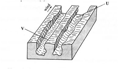
a) (ii) Name the features marked U and V.
U – Furrow (1 mark)
– Ridge/yardang/zeugen (1 mark)
b) Describe the three processes through which wind transports its load.
Saltation
It is where coarse grained sand particles are transported through a series of bouncing / jumping along the surface. (2 marks)
Suspension
It is where very fine material is picked by wind raised high and blown over long distances. (2 marks)
Surface creep/rolling
It is where large / heavy material are rolled and pushed forward by wind along the surface. (2 marks)
c) Using a well labelled diagram. describe how a barchan is formed.
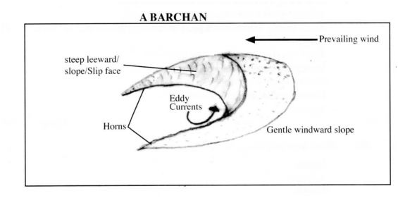
It develops in arid areas when sand accumulates around an obstacles that lies in the path of the wind. The gradual accumulation of sand fonns a hill. Eddy currents on the leeward side of the dune causes the formation of a shallow depression / concave slope / steep slope. With time the prevailing wind forces the sand at the edge of the dune to move forward forming the homs. The continuous extension extension of the homs lead to a crescent shaped feature called barchan.
Explanation any 4 x 1 = (4 marks)
Diagram max. 3 marks
(d) Explain four ways in which desert features are of significance to human activities. Desert features f0m1 good sites for tourist attraction. thereby eaming foreign exchange. Wind deflation hollows/oasis are sources of water for domestic /agricultural use. Wind deposited sands / loess form fenile plains for farming. Salty flats are economically used for salt production. Shifting sand dunes/hinder transport activities. Desert sceneries are ideal for film making. The vast sand seas are ideal for military training/nuclear testing.
Any 4 x 2 = (8 marks)
